
360+ panorama from Ceroe Grandi. As the view comes out from the hill you have Oranjestad way in the distance. Then the high rises of Palm Beach are noticeable. Then the lighthouse can be found. 360 panorama from top of Bushiribana Gold Mill Ruins.
 On my way out from the Natural Pool. In Arikok National Park. Looking west towards Oranjestad. A two image panorama. My last picture of the day.
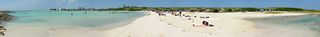 Panorama of Baby Beach.
 Panorama from the Seroe Colorado Lighthouse hill. As the view comes out from the hill you have the Cabez Reef. Then the Dunes. Then Baby Beach. Seroe Colorado is in front of the refinery. When the view is looking north up the east coast, you will see a low yellow building. That's the prison.
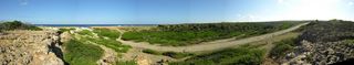 A panorama of Boca Prins. I had to bike through the water which you can see on the road coming from the coast.
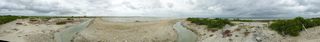 360 Panorama of the solar salt works.
 Little panorama looking into the salt flats. Possibly at Witte Pan.
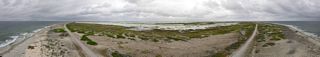 Panorama view from Willemstoren lighthouse.
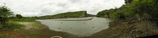 Panorama of Salina Frans.
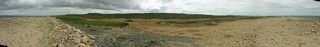 A panorama on the north coast at the turn off to Boka Onima. In the middle you can see the bike group from the cruise ship.
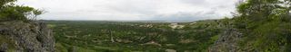 Panoramic view from Seru Largu. I walked though the woods to get this view right after I made it up there.
 Another panoramic view from Seru Largu. Where the road came up to the edge.
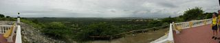 Another panoramic view from Seru Largu. Then I come to the official lookup. But I don't think it makes as good a picture.
 Panorama of the Lagun.
 Panorama of Boliva from the Spelonk Lighthouse. See bike path alongside red house. I did not know about this until chatting with a fellow as I waited to leave the island. I came by the road in the middle. And left by the one to the right.
 A panorama of Lagun Jan Thiel. Looking east. The Bon Future Prison is off the picture to the left.
 A panorama looking west at Lagun Jan Thiel.
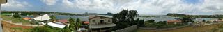 A panorama from a house that was being built on the top of a hill in Brakkeput Abbou. Like it? Call 694-2095 if you want to buy it.
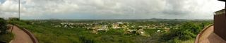 When I stopped for some water in Caracasbaai a fellow recommended I make it up Midden Seinpost (104 meters). This is a panorama looking east and south towards the water.
 I then climbed up a small observation tower and took a 360 degree panorama. The first body of water is Lagun Jan Thiel to the south. I couldn't get the horizon straight. Someday I'll try to fix it.
 I made it up to Fort Nassau. Now a restaurant. This is a panorama looking at the Queen Juliana Bridge. Taken from the front steps.
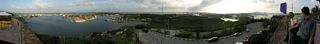 I then when up onto the fort and got a better panorama. Zeelandia and then Salina are the first towns seen.
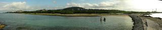 A panorama the next morning. Taken from the jetty along the Koredor Jogging Track (a.k.a. John F. Kennedy Boulevard). At the far right is the water and electricity plant.
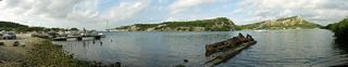 From the other end of the boats I got a panorama of Piscadera baai.
 A panorama looking south from the pier of De Octopus Bar at Boka Sami.
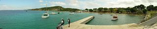 I went a little ways to the south and took a panorama looking back at De Octopus Bar. Poor fellow moved and got duplicated.
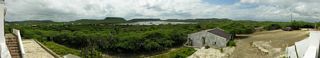 A panorama from Landhuis Jan Kok. Looking south over the salt flats where the flamingos gather.
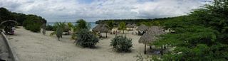 A panorama of Deaibooi baai.
 The next day I rented a car. This panorama taken west of the airport. My car is just a spec in the middle. As I was taking the pictures the sun came out briefly for two of them.
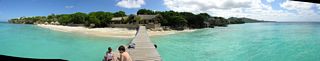 A panorama of Playa Kalki taken from the pier.
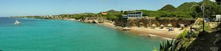 A panorama of Playa Forti from the bar/restaurant.
 A panorama from the mountain drive in Christoffel Park. Looking north.
 Another panorama from the mountain drive in Christoffel Park. Looking northeast.
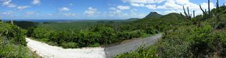 Yet another panorama from the mountain drive in Christoffel Park. Again looking northeast.
 A panorama closeup of the Boka Grandi.
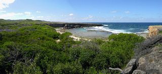 Another panorama of Boka Grandi.
 A panorama from Negrita looking across the Waaigat at Punda. Unfortunately the first picture was into the sun, so the then locked exposure was all wrong for the rest. I should have taken a throwaway picture in the center first.
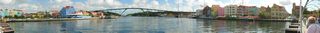 A very nice panorama from the Queen Emma bridge looking north to the Queen Juliana bridge.
© Don Wiss 2005-2026. All rights reserved.