Panorama Pictures. This is a virtual album pointing to all 90 of the panorama pictures from my February 2006 trip to the Britsh and US Virgin Islands. All stitched using PTgui.
1: The view outside my room. Foxy's dock is down in front.
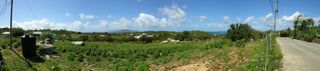
2: On East End Road. Looking at Tortola.
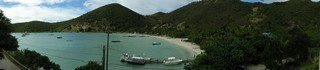
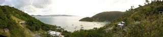
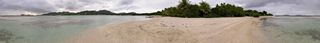
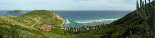
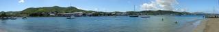
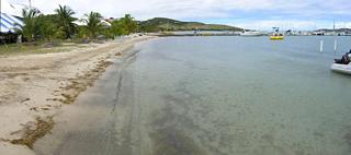
3: Looking down at Little Harbour. Abe's is the bright white largest building at the water towards the right. Scroll over.
4: Looking out Little Harbour with Tortola in the distance.
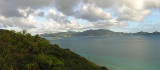
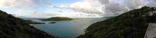
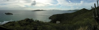
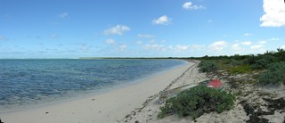
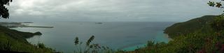
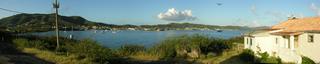
5: Looking out at Little Jost Van Dyke. The sailboats are in Long Bay. In front is East End Harbour.
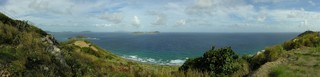
6: Looking out Little Harbour with some little islands and St. Thomas in the distance.
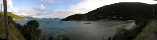
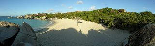
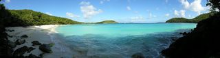
7: A small panorama of Smuggler's Cove with Gun Point. Having breaking waves in a panorama is problematic.
8: Carrot Bay.
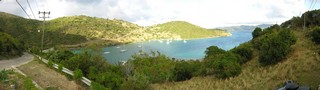
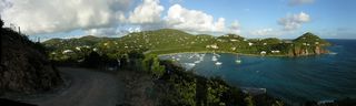
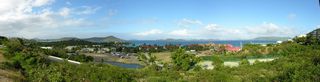
9: Cane Garden Bay.
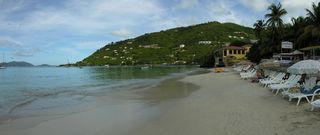
10: Cane Garden Bay.
11: Looking down at Cane Garden Bay.
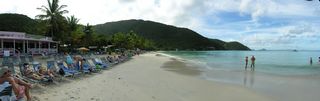
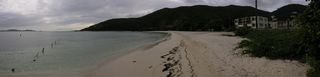
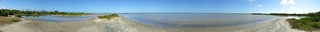
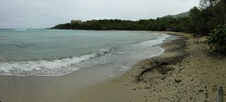
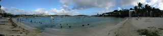
12: The panorama version of the beach at Brewer's Bay.
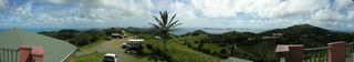
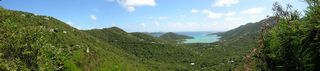
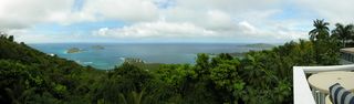
13: A wide panorama taken from above Skytop Restaurant. Looking towards the east.
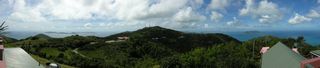
14: Another wide panorama taken from Skytop. Looking towards the north.
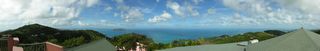
15: Another wide panorama taken from Skytop. Looking towards the west.
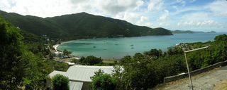
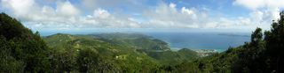
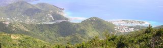
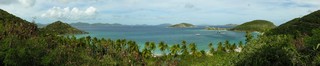
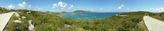
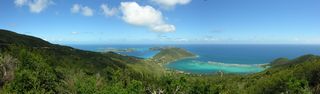
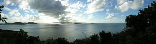
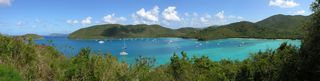
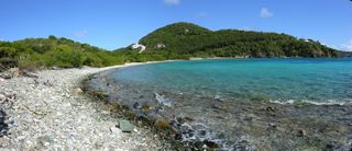
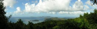
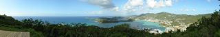
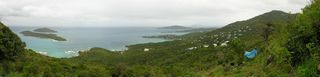
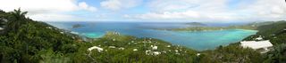
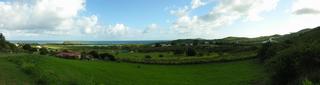
16: A panorama of the island's east end, taken from the scenic lookout on the Sage Mountain Joseph R. O'Neal Trail (#5). The bays in the foreground are Sea Cow and Nanny's Cay.
17: Another panorama of Sea Cow Bay and Nanny Cay. Taken from the scenic lookout on the Sage Mountain Joseph R. O'Neal Trail.
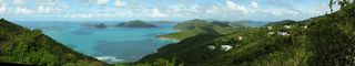
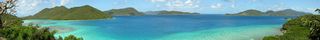
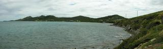
18: A panorama looking at Guana Island from Manchester, Belle Vue along the Ridge Road heading towards East End.
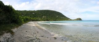
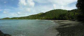
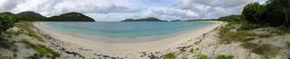
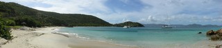
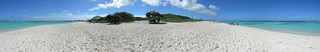
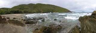
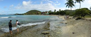
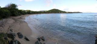
19: A panorama of the beach at Josiah's Bay.
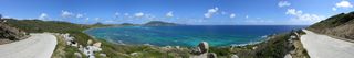
20: A more than 180° panorama of Guana Island. Taken on the road past the prison.
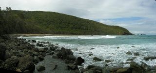
21: A more than 180° panorama of Long Bay on Beef Island.
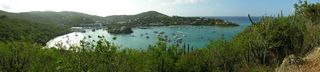
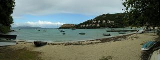
22: A panorama of Trellis Bay. Facing east.
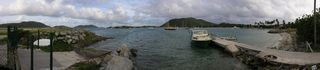
23: A panorama of Trellis Bay. Taken from Sprat Point and facing west.
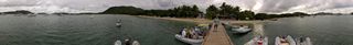
24: A 360° panorama of Trellis Bay taken from the dock in front of the Loose Mongoose. I need to output as multi-layer Tiff and mask out the fellow appearing multiple times.
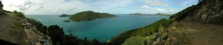
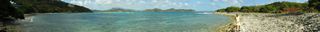
25: A 360° panorama of Well Bay, on Beef Island.
26: A panorama of the beach on the east side of Brandywine Bay.
27: A panorama overlooking Deadman's Beach.
28: A panorama of Deadman's Beach.
29: The panorama version of the previous scene. This now stretches over to include Reef Bay to the right.
30: A panorama looking over Reef Bay. Taken from a concrete slab near the communications tower.
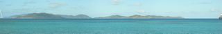
31: From "The Loop" looking southwest. The island to the right is Norman Island. In the lower right is Stoney Bay.
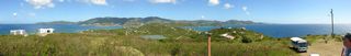
32: A panorama of Vagabond Pond. In the far distance is Flamingo Pond.
33: A panorama of Windlass Bight with Soldier Point that I like.
34: A wide panorama of Loblolly Bay and Jack Bay. Taken while standing on Jack Bay Point.
35: A 360 panorama of the salt flats.

36: A panorama taken from the rocks at Spring Bay. The morning version. [Is Little Trunk Bay to the left and Spring Bay to the right?]
37: A panorama taken from the road to the Copper Mine.
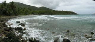
38: A panorama of Taylor's Bay.
39: Another panorama of Taylor's Bay.
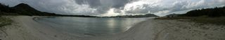
40: A panorama of the beach at Little Dix Bay.
41: A panorama of Spring Bay. This is the afternoon version.
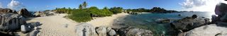
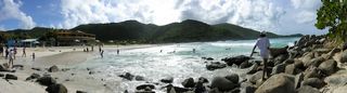
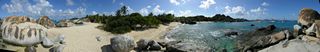
42: Devil's Bay Beach at The Baths. The panorama version.
43: An early morning panorama with Ginger Island in the foreground.
45: A panorama of the beach at Savannah Bay.
46: A panorama looking over the north end of Virgin Gorda.
47: A panorama looking west towards The Dogs. Taken from a lookout platform south of Nail Bay.
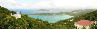
48: A panorama looking over Caneel Bay. You can see the sugar mill ruins in the right of the picture.
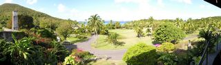
49: Looking over the grounds of
Caneel Bay from their Equator Restaurant. (To get the exposure right I should have taken a center picture first.)
50: The panorama version of the beach at Caneel Bay.
51: The panorama version of Hawksnest Beach. My attempts to get a straight horizon weren't successful.
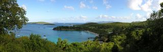
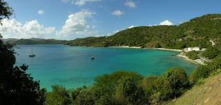
52: A panorama looking over Francis Bay and Maho Bay.
53: A panorama looking at Tortola from the Annaberg Sugar Mill Ruins.
54: A panorama of Coral Bay from Centerline Road.
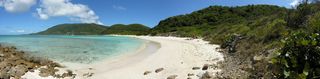
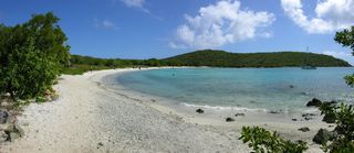
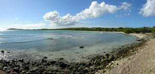
55: A panorama of Salt Pond Bay.
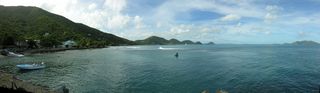
56: A panorama of Friis Bay taken in front of Miss Lucy's Bar & Restaurant. The land at the far side of the bay is East End.
57: A panorama of Limetree Cove and Limetree Point.
58: A panorama from Blackrock Hill looking northwest over Hansen Bay.
59: A panorama looking at Tortola from a lookout along Centerline Road.
60: A panorama of Chocolate Hole with Bovocoap Point.
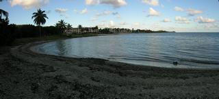
61: A morning panorama of Cruz Bay. An afternoon one would have been better.
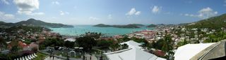
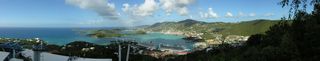
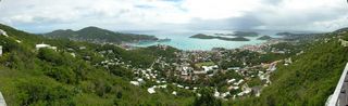
62: A panoramic view from the watchtower at Blackbeard's Castle looking over Charlotte Amalie and St. Thomas Harbor.
63: A panorama from the wooden platform at the Paradise Point scenic outlook.
64: Another panorama from a lower level at the Paradise Point scenic outlook.
65: A panorama of Water Island and St. Thomas from the fort.
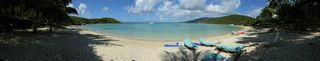
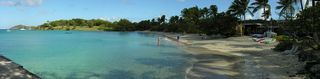
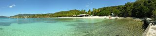
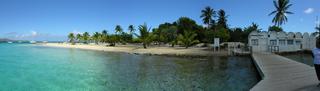
66: A panorama of Honeymoon Beach on Water Island.
67: A panorama of Perserverance Bay.
68: A panorama of Bordeaux Bay.
69: A panorama of West Caret Bay.
70: A panorama looking down at Inner Brass and Outer Brass islands. In front of them is Neltjeberg Bay. Scroll to the right and you see the mouth of Megen's Bay.
71: A panorama of the beach at Neltjeberg Bay.
72: A panorama of Dorothea Bay/Beach. There are condominiums here.
73: The non-panorama view of Megen's Bay from Mountain Top.
74: A view of Charlotte Amalie from a scenic overlook on Route 40. This is another popular stop on the tours. More parking than Drake's Seat, so there's room for some vendors to set up.
75: A panorama from The Great House looking at Megen's Bay.
76: A panorama from The Great House looking at Inner Brass and Outer Brass Islands.
77: Looking out at Water Bay from Stouffer Grand Beach.
78: A panorama of the beach in front of the Sapphire Beach Resort & Marina. Prettyklip Point is in the background.
79: A panorama overlooking the Sapphire Beach Resort & Marina and St. John Bay
80: A panorama from in front of the St. Thomas Yacht Club. Looking out on Cowpet Bay.
81: A panorama of Bolongo Bay. In front of the public beach, which here is in the distance, there is sand. I shouldn't have walked so far away.

82: A panorama looking at Fort Christiansvaern and Christiansted from Protestant Cay.
83: A panorama of Protestant Cay taken from the end of its dock.
84: An early morning panorama of Christiansted taken from Fort Louise Augusta. The fort is to the right.
85: A panorama of Shoy's Beach. Shoy's Point is sticking out.
86: A panorama taken from the intersection of the entrance to the Green Cay Marina and Route 82. The island is Green Cay. The pond is Southgate Pond.
87: A panorama of Teague Bay.
88: A panorama of the St. Croix Yacht Club.
89: A late afternoon panorama of Manchenil Bay
90: An early morning panorama looking at Sugar Beach. This is a public beach that is a popular spot for baptisms.
© Don Wiss 2006-2026. All rights reserved.
