I'm flying Delta. This is not one of my usual airlines, but in early January they had a sale to announce their new JFK -> DUB -> SNN -> JFK route. The $369 fare was too good to pass up. Especially, as Ireland was on my short list of places to visit.
We had a normal boarding. The flight is completely full. When the scheduled departure time arrives a fellow makes an announcement. Some people didn't get on. Regulations require them to remove their bags. We hear rumbling underneath. A little more than a half hour later we push off. Then we creep towards the runway. We finally take off 65 minutes after scheduled departure.
Delta has stopped offering gluten-free meals. I called back in January and asked for one. It was added to my record. But the ticket agent here claimed it wasn't an option. So I guess it was removed as an option after I made my reservation. It was real nice of them to tell me! When I fly for business I'll be sure to pick an airline that still serves them.
Dinner comes. I eat the Romaine lettuce, plus a couple of Larabars that I brought.
I try to sleep. I have no recollection of actually falling asleep. But maybe I did. The restless legs were a minor problem.
Friday, June 9, 2006
Breakfast is a banana, 3 ounces of orange juice, and more Larabars. I've never seen such small containers of juice.
A third customer has appeared. I go out to get the bus to the yard. I tell the driver that there are two other customers waiting. The driver calls in. The agent says to take me and then come for the others. Off to the yard we go. It is a long ways away. He gives me a dusty car. It hasn't been raining much here. He goes to check in a couple returning a car. I find the windshield washers don't work. I drive over to a shed and he fills the washer tank. Finally I'm off. The other two customers were kept waiting quite a while.
I pull out my Frommer's Road Atlas Ireland. I take the M50 south. There is traffic around where the toll is and the M50 crosses M1. It is easy to find my turn to Stocking Road, following the directions I was given in the rec.travel.europe newsgroup. Then I only made one mistake when trying to find it. I realized right away that I was wrong, but it was a while before I could turn around.
Stocking Road, a.k.a. R115, is windy and narrow. It is slow going. But there are almost no other cars. I stop at the Hell Fire Wood to get organized. I eat a couple more Larabars. I then decide to walk across to the Massy Wood Nature Trail. I start down a slope and my 18-200 zoom lens falls out of its pouch and tumbles along the ground. This was the first time I had used a shoulder strap. Previously I was using a belt with the cases hooked along it. So I had become lazy and wasn't bothering to zip the tops closed. But with a shoulder strap the cases slide down, and out came the lens like a projectile. Fortunately the lens itself was okay.
I looked at the Massy Wood Nature Trail, but decided not to take a walk. I drive on. At one point I approach an intersection and I'm lost. I can't find it on the map. Then I find it. I haven't gone far at all! I had thought I was much further. I continue on.
I head to the tourism office. The woman there tells me where a pay phone is, and gives me some more useful coinage. I call Atlas Car Hire. Yes, he has my card. He never gave it back to me. He has it in an envelope. He asks if I will be coming back for it. I tell him where I am. He can hold it, he says. I remind him that I'm dropping the car off in Shannon. While he could send it there for me to get, we decide it best that he cut up the card and I cancel it. Now I have to call back to the states. The bartender at the pub I'm at says best to buy a phone card. He tells me where. I return and call Chase, cancel the card, and tell them that no, I did not file a police report.
I ask the bartender about lunch. His wife is gluten-free. He suggests I go back to Laragh for food. But first, having looked at my Lonely Planet Ireland (LP), I decide to make a stop at Avondale, the Parnell estate. So I drive there. It has lots of grounds that can be walked. I decide I'll settle for inside the house. I go in. A swallow has gotten in and is flying around the two story high hall. The women running the place don't seem overly concerned. My €5 gives me a movie and a self guided tour. I did not sit through all 25 minutes. I didn't need the complete history of the Parnell family. The self guided tour only took a few minutes. This is a modest country home, not one of the grand houses, and not all that old.
I head to Laragh for lunch. I find the Lynhams of Laragh. The only things that are gluten-free and dairy-free are sliced turkey and roasted potatoes. I eat them, but they don't agree with me.
I drive to Glendalough and check in at the Derrymore House B&B. I follow the instructions from the web site. I find it. She shows me the room. It is under the roof and faces the sun. It is hot! The window only opens a small amount at the top. The curtains aren't very dark, but if I want any air I can't pull them at all. I take an hour nap. I head out to sightsee. First stop is the Monastic City ruins in Glendalough. I walk around. I find the Glendalough visitor center. I go up to the entrance. It is 5:17. It closes at 6:00, but the last person has to enter before 5:15, and the door is now locked. I don't see what all there is inside that takes 45 minutes to do.
I drive up to Wicklow Gap. I stop for pictures along the way. I wander around one stop trying to find the source of the water. It just oozes out from the bogs. The map shows another lookout just past the gap. It appears to look in the other direction. I drive looking for it. I drive and drive. Finally I turn around. Right near the gap I find it. The car park is on the other side of the road, but the view isn't.
I drive into Glendalough looking at my restaurant options. I then drive to Laragh and stop at the Wicklow Heather Restaurant. The wait staff is young. Not professionals. (I have to ask to have the unused place setting removed.) She has to go to the kitchen a couple times to check on ingredients. I did end up with a very nice chicken breast and salad.
I drive over to Upper Lake. The car park sign says it is open 9 AM to 8 PM. It's now 8 PM. There are cars in it. I park and start walking along the lake. I meet a fellow. I ask about the car park time. He says I had better move the car outside of the car park and park on the road at the double yellow lines. And he suggests walking along the lake to the old miner's village.
So I walk back to the car park. As I approach a fellow is lowering a barricade. He says he won't lower the other one until 10 PM. So I leave the car and head to the miner's village. As I approach it, I stop and let a couple approach me. We chat. They recommend the Poulanass Waterfall trail; and for me to take my car out of the car park.
I returned to the car park. I moved the car. I shouldn't have to move it. It's 9:15 and the walk is listed for 45 minutes, which would be for a slower walker. I head over to it. The placard describes the walk going in a certain direction. But when I get there I find pink arrows going in both directions. So I pick one. It turns out that I went backwards. This meant that I reached the falls at the end of the walk, instead of the beginning. As twilight was approaching it was darker and worse for photography when I got to them. Plus, as you walked you had to look backwards to see the falls. So if you are ever there, anticlockwise is the correct direction.
I head back to my room. It was close enough that I could have walked. My room is still hot. I leave the shades up for maximum air circulation. I sleep on top of the sheets.
Saturday, June 10, 2006
I get up at 6:20. The room has cooled some. One could now sleep under a sheet if one wanted. I shower and I'm out for a walk at 7:00. I walk around Lower Lake, which is the view from my room. There is no wind. The lake reflects nicely. I get many good photos. I'm back at my room by 8:00, the time breakfast starts.
Breakfast consisted of orange juice, lots of bacon, two eggs, a couple of small tomato halves, and some mushrooms. It was all very nice. But satiation did not last long.
I'm off at 9:15. I head to Rathdrum. Then I head to Avoca. I see a sign for Avoca Handweavers (a big tourist trap). So I follow the signs. I check out the shop. I look in the windows of the weaving room. Being Saturday it was quiet. I walk around. A tour group is there. I head on.
I approach Arklow. We go under the N11. There is no connection there. So I had to drive through the congestion of Arklow to pick up N11 south of it, at a grand intersection. But N11 has shops, driveways, and small roads off of it. I see no reason why R747 couldn't have had a small connection.
I walk around Courtown. It has a pretty harbor. It is nicely sheltered from the sea. This is a popular tourist town; for its beach and related attractions. But the beach isn't much. Ireland may not have grand beaches on this east side.
I head south. I make a detour to Roney Point. Then I head back to R742. My next detour is to Cahore Point. There are some beaches here and a jetty where people go crabbing. It's now noon. So I walk up to the only restaurant. She only has soup and sandwiches. I head back to R742 and move on.
I pass a windmill farm. I stop for a picture. I get to Kilmuckridge and see a bar with a real restaurant: Seán Óg's. I go in. When I say I'm gluten-free and dairy-free she suggests a starter salad with chicken. But I want a full meal! So she figures out that the chicken special is fine without the sauce (as the chicken is cooked plain). Then there is no olive oil, so I have the baked potato dry. For less than the day before (but more after the tip), I end up with a much better meal.
I continue south on R742. I reach Curracloe. I drive over to the beach and get a couple of pictures. On my way back to my car a woman and a small boy are watching a small lizard. They had never seen one before. They wanted to know if I wanted a picture. A brown lizard on light brown sand would not have been overly exciting. I passed, but thanked them for showing it to me.
I drive into Wexford. I park at a pay and display. There is no free parking in this town. Every square foot is either a road, or has cars parked on it. Even the church cashes in by charging to park in the church yard; except Sundays. I walk along the waterfront and stop at the tourism office. I pick up a town map. I try my Commerce Bank card at an AIB ATM. It works! I only take out €220. There are AIBs all over Ireland. I walk over to Main St. I find the Selskar Abbey and the West Gate (part of the old town wall). Originally there were six town gates and they were used to collect tolls. I get back to my car a few minutes after my hour is up.
I head towards Rosslare Strand. I check out the beach. I head to Tagoat. I take a picture there using my telephoto lens. I then head to Lady's Island. While changing my lens I see that on my telephoto the switch for manual focusing was flipped. I think I did that early in the morning. I know the church picture is bad. Maybe many others I took during the day? One problem with SLR cameras is they have so many switches that one can easily be set wrong.
I drive to Broadway. The driving tour book has one going to Twelveacre Cross Roads. But I miss a turn. I realize it, but with my GPS showing the compass I know I'm heading in the right direction. So I keep on going.
At Tomhaggard I stop at a pub and check with some fellows to be sure where I am. I then head up to the main road to get back on the route.
At Tenacre Cross Roads I turn down R739 to Kilmore Quay. I get there just at 5:30, which is just when the museum closes. I wander around. I'm hungry. I look into an expensive white table cloth restaurant. I don't need that! Then I see what the Quarterdeck, a fish and chips place, has. Their chips are fried in their own oil. Only burgers are cooked on the grill. So for €3.75 I have a large dinner. All wrapped in paper. And eaten in the car.
I follow the back roads to Duncormick. Then I head to Wellingtonbridge. But I miss a right turn and end up in some cul de sacs. It's a peninsula. I have to backtrack to get out of there.
I pass through Wellingtonbridge and take R733 towards Fethard. I had noticed something about Tintern Abbey, but I missed it, and I didn't realize that until I was in Fethard. I don't go back. So for a substitute I checked out the ruins of the Fethard Castle.
I then drive down to the bay at Baginbun Head. I then head toward Hook Head. I thought it was a town. I was thinking it is getting time to look for a B&B. But all I find there is a lighthouse and a lot of caravans. So I follow the road to Duncannon. I pass a B&B, but decide I can go further and then look. It isn't sunset yet. I look at the abbey/castle in Duncannon from the outside. I then head to Arthurtown. I stop and look at the beach. I chat with a minister, who is out walking his dogs. It's getting time to find a place to spend the night. I pass one B&B, but don't go in. I come upon another. She wants €60. The place was a bit fancy. I pass. I head to Ballyhack. Nothing is there but a ferry. I chat with a couple of waiting for the ferry. They say if I head back to the coast there will be many places. And there are places on the way to Waterford. This is where the tour I'm following goes. I cross over to Passage East.
I find the yellow hotel. It was fancy. So I decide to drive into Waterford. I find the Quality Hotel. Again it is fancy. She's full, but she knows that the Tower Hotel has rooms. It's even fancier, she says. She points out that there are no B&Bs in town. I ask what she would charge this late if she had a room. She says €79. I head to the Tower. The woman behind the counter quotes €89. I counter with €79. She takes it, as long as it is just one night. I ask about the hostel, for which I saw a sign. She says they are no longer taking guests, just refugees. I head up to my room to catch up on my journal. I end up getting to bed at midnight.
Sunday, June 11, 2006
At 4:45 AM there are some loud guests in the hall. There may have been a wedding the night before. I had forgotten to pull the opaque curtains. So I do so. I try to get back to sleep, but not really. At 6:30 I get up to plan my day.
I go down at 7:20. As breakfast isn't until 7:30 I go out for a walk along the quay. The Tower Hotel is not in my LP, so I ask where I am. I find I'm across from Reginald's Tower. I then find Christ Church Cathedral and the ruins of the French Church.
Breakfast is a buffet, so I can eat a hardy one. I go out and wander around the town, trying to find the sights mentioned in my LP. It isn't all that easy, as not all roads are marked, and in the LP not all roads are named. I eventually find all the sights. So I head back to my room.
I check out. Reginald's Tower is now open. I go in and check out the exhibits. The view from the top, on the outside, is only for guided tours. While one was to start in five minutes, it would last 40. The only others inside were a couple wandering around. It is possible that I would have been the only one of the tour. And if so, I could have gone outside first and then ended the tour. But I didn't think of all this until afterwards, so I didn't stick around to find out.
I've decided to backtrack some and pick up the coast again. First stop is Passage East. I get out and walk around some. It is picturesque. Then I head south towards Dunmore East. Along the way I stop at the Arsenal ruins. It is privately owned and part of a farm. I settled for a picture of part of it.
I continued far a ways until I came to a police barricade. I had to turn around. I asked a pedestrian what was up. She said they found a body there, and they had to investigate before they removed it. Another car came up. I filled them in with the story. They were also going to Dunmore East. They said they knew the shortest way around, and I wouldn't have to go all the way back to halfway between Passage East and Waterford. They said I could follow them. We did go most of the way back, but avoided going through Passage East and the steep hill beyond.
We were turning in a road, which they said would come out just below it, but we came upon another police barricade. (I gather the body was at that intersection.) But the couple knew all the roads and I kept following until we got to Dunmore East.
I parked at the first spot I saw. I was near the beach, not in town. I went into the bar, found a pay phone, and booked a room in Cork at the Kinlay House Hostel.
There is only one restaurant at the beach. I asked a couple of women about food. They told me there were more places to eat in town. And that it was just a walk up the hill. They say I should be lucky to have the parking spot. (I write they, as both tended to say the same thing.)
So I walked up the hill and into town. I checked out the park along the way. I got some pictures. There were plenty of parking spots in town. I looked at the few restaurants. They were all expensive, except one. And it was packed with no available tables. It was mostly a deli place. So I decided to head to Tramore for lunch.
I took the unclassified roads along the coast. Tramore is a much bigger town. Lots of seaside amusements, and lots of fast food restaurants. I walked into the first one I came upon: Misty's. Every dish included chips. They were contaminated with wheat. They had nothing to substitute, except she offered me wheat bread. I asked her what dishes were gluten-free. She had no idea. I left.
Across the street was a hotel with a restaurant. They were serving as a carvery. I could have the meats, but the roasted potatoes were cooked in the deep fryer. All I could have were meat, carrots, and ugh, cabbage. For €9.95. The size of the meat portion would be the same.
My next stop was a fish & chips place. I think it was part of a chain. I asked the woman taking orders about what else was in the fryer. She didn't understand what I was asking. Apparently English wasn't her language.
My next stop was a "trailer" parked just inside the amusement area. (I later learned that it is called a chipper.) It sold burgers and chips. No fish. Only chips and some steak go in the fryer. Only burgers go on the griddle. So I order two 4 oz burgers (Why ounces? I thought Ireland was metric?), chips, and the burger fixings as a side salad. I ended up stuffed.
I had spent an awful lot of time finding lunch. I got some pictures and headed towards Dungarvan, going along the coast. It was a lovely drive; another marked route. There were many opportunities to stop for pictures.
I arrived in Dungarvan around 4:30. I wandered around. There would have been a tour of the castle at 5:00. But it would last an hour. I stopped in a hotel to use the pay phone. I was thinking instead I could stay in Lismore (and cancel my room in Cork). There was no answer. So I headed off to Lismore.
I get to Lismore at 5:45. The castle grounds were closed. I, and a few others, parked and walked up to look at the outside. One fellow I chatted with suggested I take the Vee on my way to Cork. He says there are signs to it.
It only took me a few minutes to see all the sights in Lismore. It was a good thing that the B&B didn't answer! It was now a little after 6:00. The Vee takes me in the opposite direction from Cork. But I had lots of time. So off I go. This is a most scenic route and I stop for pictures often. Many of the others driving the route also stop.
Others stop and I wave them on. But some stop anyway. There is talk of using a rope to pull me out. Then one says the fellow with the rope left. There were about four cars stopped. There was much discussion as to which way I should be pulled out. Since I backed in I wanted to be pulled out from the front. One fellow knew that there were plastic covers covering towing sockets. Another (same one?) knew that towing pins would be with the spare. A rope appears. One fellow has a tow hitch on the back of his car. While we are discussing all this, the woman (of the family that stopped first) returns to the scene. She says the tow truck will be there in 20 minutes. She isn't too pleased that we are trying to do it on our own. She gives us the number 052 65198, and asks that we call if we no longer need him.
We hook everything up. There was no problem pulling me out. We're sitting in the middle of the road when two large tractor trailers pull up. They want to get through. We move the cars to the side. They pass. Then a fellow gets the rope untied. He had to use a Vise Grips. The force tightened the knots up. I collected the towing eye. I thanked them all profusely. And then I headed on my way. I could detect no visible damage to the car! (But later I realized that though I got the rhododendron picture, I took none of the car in the ditch.)
I count the bridges. I bear right. I see signs for Kinlay House. But I had to stop and see if that was the name! I find a parking spot right across the street. I go in. I have to wait a while for the desk fellow to show. I find out that the breakfast is a light one. That means only orange juice for me. But I can buy my own food and cook it in the kitchen.
I drop off my bags. I ask him to point out the Indian restaurants. He gives me a map and marks two. I look at the first one. Then I go into the second, Bombay Palace. The fellow thinks that flour is not wheat. Other than the cream oriented dishes, he said they can just leave out the butter for me. The food is fine. I write out my notes for the entire day.
I headed back to my room. It was 10:30 and the supermarket would be closing soon. The fellow at the desk said it is up the hill. So I went to where the steps leading to the alley where the hostel is. I looked at my car's parking situation. While not at a double yellow line, I was not legally parked. I walked up the hill. I reached St. Anne's Church. I walked down the next road. And there was a curry take out! I chatted for a minute. They were Pakistani. I kept going. And there was the supermarket. I bought bacon and half dozen eggs. I continue down the street. I ended up at the river, but very far from where I expected to be. I walked along the river until I recognized the road leading up to the hostel. I walked up. I asked at the desk about the parking. They explained how to bring the car into the alley in front of the hostel. I did. Now I'll have to back out!
In my room I looked at the maps to decide what I should do. I didn't get to bed until 12:25.
Monday, June 12, 2006
I awake at 6:20, but didn't get out of bed until 6:45. The kitchen is already open. I hope I can still get there before the crowds. It's quiet in the place, so it would seem so.
No one else is in the shower, but surprise! Even though the sinks have hot water the showers are cold only!
There are only a few at breakfast. No one else is cooking anything. I ask at the front desk about the ship museum that my tenant recommended. They think it's the one where the Titanic sailed from. At 8:20 I head out to see Cork. I cross over the river and head down Main Street: North and South. I find an old church. I then walk over to the Cork Kerry Tourism office to ask about the ship museum. Yes, it's the Titanic one. It's over in Cobh. It has a lot about Irish emigration, which I'm not interested in. There is very little Irish in me. I walk though Bishop Lucey Park.
It's 9:15. It looks like I have enough time to get to the Cork City Gaol and then back to check out of my room at 10:30. So I head that way. I came upon the River Walk. From the map it looks like it may end before the City Gaol. So I gamble and take it. About halfway there is a turnoff. I take it. I come to a complex. Above is a cliff. I need to be up there. A fellow comes by. He says I can't get up. I either have to go back to the beginning, or if I continue on, I'll have to cross the river and then at the sports complex cross back. I will be overshooting the Gaol. I decide I'll go that way. It will be different. I will then return via the streets.
I walk and walk. I cross over the river. It looks like where I'm crossing over is already past the Gaol. I start on the other side. A fellow is also walking. We chat. I note the many driveways with signs for B&Bs. He says one street over is lined with them. He's staying at a hostel there. He walks on with me to be sure I find the turn to the pedestrian bridge. I continue on. When I get across I see a sign for the Gaol. I had not gone very far past. The first bridge I crossed over wasn't on the map. I was thinking that the one on the map was the first one.
I get to the Gaol. They're big on this audio guided tour. It has history plus stories of some of the prisoners. It suggests stopping the tape when you walk to the next stop. I never turn it off. It is slow going. I can even go to the men's room and back without missing anything. As we approach the end I've had enough and I cut it off. This all took longer than planned. I won't make the 10:30 check out time. I walk back fast. It is almost 11:00 when I get my bags out of the room. I put them in the boot of my car.
I head back to Cork center. I find some banks to try my Commerce Bank card. Even at an AIB it wouldn't work. I get a variety of responses: that service temporarily unavailable, invalid transaction or amount, etc. At the AIB the customer service rep tries to swipe the card. She says it can't be read. But all the machines say they are contacting my bank or society. If they couldn't read the card how do they know what bank to contact? The card is brand new and shouldn't be bad. [After I got home I tried it and it worked fine.]
I head to the Red Abbey Tower. Then I take the back way to Saint Fin Barre's Cathedral. I pass the Elizabeth Fort, take note of it, but didn't know what it was, as it isn't on the LP map.
At Saint Fin Barre's Catherdral the fellow taking the money sees my camera. He says he has the same one. I ask if he has a D200. He says yes. I show him my 18-200 lens, which he doesn't have.
A service is starting. I quickly walk around and snap a few pictures. Then I stop and chat with the fellow. He says Nikon lens are really expensive in Ireland. We exchange e-mail addresses. This so I can send him suggestions of where to buy in the US.
As I was walking away I realized that for all my indoor pictures I've been using the wrong lens. The wide angle works well indoors, but it doesn't have the needed image stabilization!
I walk along South Channel and get a picture of Holy Trinity Church. I then walk on and get a picture of Cork City Hall. I then walk to St. Patrick's Street to try another AIB ATM. But there were nine people waiting for the ATM. No other ATMs have lines. Only this one! I then walk to the Little India restaurant that I had seen the night before (after I had eaten). They had a buffet. Great! But I was the only one there and I was the first to use the serving utensils. There was no butter in anything. There was just cream in the one cream-based dish. It was my best meal so far. All for €9.95.
I head back to the hostel to get my car. The woman at the desk gives me instructions on how to pick up the N20 to Blarney. I only missed one turn and had to turn around to get it.
In Blarney I parked near the Blarney Castle. I went in and climbed to the top. I did not wait in line to kiss the stone. The castle is set in 1000 acres. For some reason the nearby Blarney House was closed. A sign mentioned a 45 minutes and 1 1/2 hour walk. I head for the 45 minute one. It was not well marked. I walked through the Rock Close. I found the Wishing Steps and the Witches Kitchen. It may have been 30-45 minutes of wandering around. Then I left.
Back in my car I tried to figure out how to get to Kinsale without going through Cork City. I asked in a nearby gift shop if there was a tourism office. She told me where. I figured I could get them to print a route from the web.
I went there bringing my B&B books. I was thinking of booking a room. I didn't bring my maps. She had a preprinted route slip for getting to Kinsale. Apparently it is a popular next stop. But it went through Cork City. A route from the computer would also go through Cork. I buy from her a local map and she marks the non-Cork way. Problem is the map I bought is old, and a bunch of new roads aren't on it. Plus the map cuts off just below Cork.
I head out. I do get lost a little in all the new roads. I finally figure it out. The compass on my GPS is very helpful. I still made good time getting to Kinsale.
In Kinsale I park in the first spot I see. I have to ask a couple times before I find the tourism office. So I get a little walking tour. It is a very pretty town. At tourism I pick up the free map. I walk along the water. I head to The Courthouse and Regional Museum. The last entry is 4:15, and it is past that. So I find Desmond Castle. They are still open for a while. It is now mostly a museum on wine, especially wine in Ireland. I chat with the woman about how the Germans brought beer to America, and the Romans spread grain farming around, and how their diet eventually became entirely grain based (plus olive oil, salt, and wine). These are all non perishable and can be transported.
Next I walk up to the St. Multose Church. Then I head back to my car. I see that I'm parked in a disk zone. I'll have to learn what that means. [I never did.] I then recalled something about Carmelite Friary ruins. So I head up the hill. The ruins aren't much. Not worth the hike. I then read about Charles Fort. I head there quickly. I got there too late. It closes at 6:00, but last entry is 5:15. It was now 5:40. I took a picture the best I could. I got back in my car. Then seeing a sign for a marina at first right I headed past the fort. I came upon a parking area and a sign for a shore walk. So I took it. I got a good picture of Charles Fort from the water. A view few tourists see. I then headed towards the marina. It was private, so I didn't go in. It was a wasted side trip.
On my way back to Kinsale I stopped in a pub. I now knew that Clonakilty was where I wanted to stay. I called a place from LP. It was full. I asked for a suggestion. He suggests the Townhouse. I called. Yes, he had a room. He told me how to find them and it would be €45 with Irish breakfast. I told him it would be a couple hours. (It was three.)
I headed off. After crossing the Duggan Bridge I turned the opposite way I wanted to go and went to Castlepark. I looked at the boats. I asked a couple about this other road that was paralleling the main road. They said it would meet up with the main road later. And that it was more scenic. (As I write these notes I learn that I was right next to the Fort James ruins. On the map it looks quite grand. I should have taken a look.)
I took the unclassified road. There were stunning views. When it met up with R600 I turned and took more unclassified roads to get to Old Head. I got stunning views, and many pictures all along the way. In Old Head I went as far south as I could. There is a private golf course at the very end. I then came up the other side of the head.
Along the way I stop often for pictures. At one point I split off the main road. It was more direct, but slower. But being slower I could appreciate the views more. As it was meeting up with R600 I asked a walking couple about whether I should take more unclassified roads. They said no, but suggested I make a 10 minute detour to Courtmacsherry.
I continued on. I took more pictures. In Timoleague there are some grand abbey ruins. I didn't know it they are ever open, but it was late now. [The gardens are open and I could have stopped.] On my way back from Courtmacsherry I found some small abbey ruins. I stopped for a quick peak.
I headed straight on to Clonakilty. I easily found the Clonakilty Hotel. It is large and new (six years old). There is parking in the rear. The room was large. Everything was spotless. It had lots of little touches you'd expect in a luxury hotel. But there were few guests. I see a rack full of unused keys. [I later learn that he's fully booked every weekend through August.] The owner tells me where the Indian restaurant is.
I dropped off my bags. I collected up what I needed to write my journal. I headed to the Cobra Tandoori restaurant. Noticing in Cork that the take away price was lower than the eat-in, I asked. This was also true there. So I figured I could eat in my room, at the desk, and write my journal there. I chatted with the fellow. They were also Pakistani.
Back in my room I ate. And I ended up spending a couple of hours writing the journal for the entire day. I get to bed at midnight.
Tuesday, June 13, 2006
I get up at 7:00. I'm down for breakfast before 8:00. I chat with the fellow running the place. He checks my employer's home page and finds that they did consummate the takeover on Monday. I learned that the US got clobbered in the World Cup. My supervisor went over to see that match.
He offers me black pudding. He says there is only blood and spices in it. But it comes out with seeds. He checks the web. They are oatmeal seeds. In Ireland oatmeal is considered gluten-free, but it isn't in the US, due to contamination with wheat. As some celiacs can't even handle pure oats, I pass.
I go out and wander around the town. It's a pretty town. It gets packed on weekends, but it is quiet in Tuesday morning. I find the Roman Catholic Church of the Immaculate Conception. Then I find the post office, which is in an old church. Then I find the older Church of Ireland, Kilgarriffe. It's on a hill with lovely views over the town. Then I stop at the museum. It's not open until 10:30. Then passing the Roman Catholic Church again I go in. There are a couple of people praying. I didn't want to switch lens, plus I thought a camera shutter a few feet away from one of them would be an intrusion. So I took no picture.
I found Emmet Square. It is okay. I found the Old Town Hall. I walked back to my room.
I got my things, checked out, and headed for Templebryan Stone Circle. I drive too far. I come back. I ask a fellow for directions. He says it is just in front of the barn with the green roof. The problem is with the hedges I never see it again. [As I type this in and look for a link, I think I see it in pictures on the other side of the road from where I was looking.] On my third pass I see it along the road. I turn around and find a place to stop. It's in a field and you can't get to it from the road there. I take a picture over the hedge. I return to town. That was almost a half hour. It was not at all worth it.
My next stop was the Model Village and Road Train. This is a cute tourist stop. It has models of some of the nearby villages, with model trains running around.
I continue on. I make the turn down to Castlefreke. I come to a four-way intersection. It was Castlefreke. I thought I was at a different intersection. So I went straight through. I ended up going through Castlefrekewood and around a salt pond. I found a bunch of surfers. I got some lovely views. It was good that I missed the turn!
I head towards Rosscarberry. But I see a sign for a cliff walk, off a cul de sac road. So I take it. I was rewarded with lovely views of Rosscarberry Bay.
I make it near Rosscarberry, but I'm now on a national road (N71) and it doesn't go through the town. I then turn off on R597 and head towards Glandore. As I approach I realize that I had forgotten about the Drombeg Stone Circle. So I drive back a little and turn off towards it. I find a lovely circle with lovely views. It was well worth visiting. There were some boards explain what we see, which in addition to the circle, has a pit for heating stones and then rolling them into a trough with water to cook food. I chat for a while with an Irish couple who were just beginning to explore Ireland beyond their local region.
I drive into Glandore. There are two restaurants. Both just serve things like soup, salad, and sandwiches. I want more than a salad, so I continue on to Union Hall. (Later, when working on these notes I pull out the driving tours book. It recommends a stop in Leap to climb the hill for the beautiful harbor views. It would have only been a couple of kilometers out of my way. LP, which I was following for this day, doesn't mention Leap.) Union Hall is a large town I find out. It has various restaurants. I stop into the Dinty's Bar. Most of the things are fried. But there is a steak for €21. I end up with a large steak, onions, mushrooms, potatoes, and salad. It was a hearty meal.
I chat with the proprietors. Their son owns Lucky Jack's, a bar in NYC. They give me a card. I tell them I want to get to Baltimore without going up to the N71. They write out instructions. Turn right at the church, that was easy, then left at the creamery. I never found it, but I went left anyway. I guess I was following the compass. Then when I'm in Castletownshend I'm to take the coast road to Tragumna. This last bit was the most useful.
I got to Castletownshend and drove to the harbor. There were lovely views of Castle Haven. Then I head to Tragumna. I passed a sign to Castlehaven Castle. So I took it. I found a church (or cemetery chapel) ruins and a cemetery over looking the bay. I passed a sign to Toe Head. So I took it. I got a view of Toe Head Bay. I did not drive up to Toe Head itself.
I reached Tragumna Beach. But it wasn't on the map. Instead it has the village of Bawnlahan, which doesn't get sign posts. I found a woman sorting out her glass into the various glass recycling bins. I knew she had to be a local. I got a piece of paper and wrote out the instructions to Baltimore. With a lot of compass following I probably could make it, but instructions made it easier. She gives me: up hill to top (actually it was the second hill), then sharp left, next right, next left, next right, second left (first left was a cul de sac). While that didn't get me into Baltimore, it was easy from then on. She also mentioned a forest.
As I passed the Knockomogh Nature Reserve there was a car park with cars. I pulled in. I walked a little ways in. The ivy covered trees all looked the same. I walked out. I found a couple. I asked if there was anything besides trees. Yes, they replied. At the top there were good views. How far? It is about a half hour. Which way is the shortest? They weren't sure, but thought if you turn left off the path as you go in. I hiked up. The views were good. I came down a different way that was shorter. Only 20 minutes to get down. As I was returning I realized I'd left the GPS in the car, with it on. Whenever I get out of my car for something, like a meal, I always forget to turn it off. And that is rapidly draining the alkaline batteries. (I only bought it a couple days before I left, and I wasn't able to get an international independent-circuit charger before I left.) I did look at the map and saw I climbed 197 meters (646 feet).
I headed into Baltimore. I stopped at the boatyard. There was nothing photogenic. I drove out to the Beacon and climbed up to it. I was rewarded with panoramic views. I then drove towards Skibbereen. Along the way I passed the Creagh Burial Grounds. (Also someone famous is buried here: Canon Goodman, but he meant nothing to me.) So I parked and walked in. Some of the graves were new, so it is still being used. In the center was a memorial chapel, in a bit of disrepair.
I drive into Skibbereen. I parked and found a pub to book a room for the night in Schull. I pulled out my wallet, but I couldn't find my phone card. I had left it on the phone when I booked my room the day before. I went to a deli nearby and paid €5 for another. The first had more than enough time for the trip. So this was €5 down the drain. The first place I called, Glencairn, on Ardmanagh Drive [now closed], had a room for €40.
I drove around Skibbereen. I was unable to find any park or river to walk in. So I stayed in my car and continued on. The LP mentions the Abbeystrewery Cemetery. Some 8000-10000 famine victims are buried there in mass graves. I passed it, but it was a national highway and there was no place to stop.
Looking at the map I see I can detour through Kilcoe to do at least some of my trip to Schull not on a highway. So I looked for a sign. I found one and made the turn. But the compass directions were all wrong. I kept on going until I reached water. This wasn't supposed to happen. I drove back up and stopped by a couple. She explained that I missed the first two turns to Kilcoe, and the one that I took was perpendicular to the one I wanted to be on. She said just go back up a ways and make the next left. I did, and had a lovely drive on a single track road with grass growing in the middle. Though, the hedges were a bit high to have much in the way of views.
I get back on the highway. I go through Ballydehob. I didn't see anything special. I continued on to Schull. I arrived a little before 8:00, though I didn't realize this until it was a little after 8:00. LP mentions Adele's to eat at, but it closes at 8:00. I drove down to the harbor. I see a sign for the Foreshore walk. So I take it. I stop a couple and ask how far it goes. It is about a mile, was the reply. It goes out to the cemetery and then back on a road to town. We chat for a while. They suggest the New Haven for dinner. Then I head off. The best view of the cemetery and chapel has the sun right in my eyes. I walk back along the road. Going all the way into town will be going past my car. I ask a woman. She says that at the next road (The Moorings) I can walk down and get back on the shore side path.
I get my car and head to the B&B. Martin, half of the couple running the place, gives me a walking tour map. He suggests going for dinner now. And he also suggests the New Haven. I find it, but it was closed. I walk into the Black Sheep. It is now a little after 9:00. They stop serving at 9:00. I walk around. Every place else, except for the Oriental take away, is closed. Either they are not open for the season yet, or not open on Tuesdays. So I settle for the Chinese take out.
The young woman at the counter doesn't speak English. So the fellow cooking comes out. His English is flawless. He says there is no soy sauce in the Schezuan dishes. So I get one. But what makes the sauce brown?
I go eat in my room and write these notes. It was early to bed: 11:10.
Wednesday, June 14, 2006
I'm out for a pre-breakfast walk at 6:30. Breakfast isn't until 8:00. I walk part of the Collapier walk. Then I drive the entire route. I'm back for breakfast at 8:10.
I ask for four eggs. I only get three. But I see he reduced the tomatoes and mushrooms to compensate. Most people fill up on the bread and cereal. It's hard to get more of the things I eat to compensate for the things I don't eat.
As I head out I ask Martin if he has any suggestions as to walking tours that I can drive. He suggests driving up to the top of Mt. Gabriel, if it is a clear day. It is. So I head that way. Along the way I stop to take a picture. The GPS isn't picking up any satellites. So I set it on the wall alongside the road. I walk a ways, take my picture, get back in my car, and drive off. On my way to the top I realize I've left the GPS behind. There are so few cars on the road that I figure it will still be there on my way back. At the top of Mt. Gabriel the views are stunning. I head down, picked up my GPS, drive through town, and head to Goleem.
Martin had mentioned an altar rock to see on the way. He said when I pass the Altar Restaurant I've gone too far. I see the restaurant. I turn around. I drive a little ways back, but I don't find it. [Here is a picture of Altar Dolmen.]
As I approach Goleem I make a little side road detour. Hopefully my GPS waypoint will tell me where it was.
I get into Goleem. I drive down to the harbor. One of my guides says something about a beach. But I don't see where one could be. I drive up the hill to look at the church. I head on.
The drive to Crookhaven is lovely. It's all lovely out here. I arrive in Crookhaven. I look around. I drive as far to Streck Head that I can. Then it turns into private roads. Back in Crookhaven I check out the food. It is 11:30 and I'm already hungry. That's only three hours from breakfast. The breakfasts I cook for myself at home can keep me satiated for more than six hours.
The first place, O'Sullivan's, won't be serving for 20-30 minutes. It's all sandwiches, but he can give me the ingredients on a plate without bread. I check out the second place. They don't start until 12:30. I head on.
I pass a sign for Brow Head. This does get mentioned in the guide books. I drive up, and walk to the top. It was very much worth it. I drive down. I could return to Crookhaven for food. I pull out my LP. In Barley Cove there is a hotel that serves food. It will be my last chance for a long ways. [Not really, I later learn that at Mizen Point they sell food.] I decide I will head for that. Along the way I get some pictures of Barley Cove Beach. There are two parts. There are only a few people on the smaller fork. More in the main one, but considering the size you still have many acres per person.
I get to the Barley Cove Hotel. It's fancy and pretty quiet. There are not many guests around. But they are serving food. The chef comes out. We discuss the various options and what he can do. I can have the soup of the day (pureed celery and carrots), a burger, and potatoes cooked in a pan. I tell him I want a hearty meal. I start writing my journal. I get to the GPS story. I go out to my car to turn the GPS off.
The soup is large. The burger is pressed by hand with onion bits. He gives me lots of potatoes, plus a small salad with balsamic vinegar. Yuck. I pick the tomatoes and onions out of the salad and eat the rest. I'm stuffed.
I head out to Mizen Head. The parking lot is huge. There was only one tour bus and about a dozen cars. I go in. There are many people sitting and eating. I pay to walk to the lighthouse. Only a few people are doing this. I guess the others already went, or were too elderly or infirm to make the walk. At the lighthouse there is a little museum. I chat with the fellow there. He says in summer there are crowds of people (school is still in session, so it isn't summer yet). The road out there is narrow. For years there has been a fight over widening it. Outsiders want to widen. Locals don't. I get pictures. I walk back. The bus is still there. I head on.
I easily find the turn to the unclassified coast road that splits off just past Barley Cove. I get lovely views of Dunmanus Bay and Sheep's Head Peninsula. After a ways I reach R592. This is more inland, and the views aren't very good.
I reach Durrus. I decide it's time to book a room in Bantry for the night. I stop in O'Súlleabháin (O'Sullivan's) pub. I order tea. It will be hot, as that is the only way it is served in Ireland. This is my first caffeine this trip, but I was getting sleepy as I approached Durrus. I phoned the Atlanta House. They have closed the fellow answering says. I ask for a recommendation. He suggests the Vickery's Inn. I phone. A single with a shared bath is €28. I take it. [It closed in 2007 for a massive apartment/shop complex.]
My tea comes. I ask for a glass of ice. She partially fills it. I ask for more ice. She puts some more in, but doesn't fill it. I gather she's never made iced tea. I pour the tea over the ice. It all melts. While not completely iced I can now drink it quickly.
The guide book mentions a garden in Durrus. I ask where it is. She says it is just across the street and over there. I go over and find the Carraig Abhainn Gardens. I pay inside their garden shop and wander around. I find a flyer listing other gardens in the West Cork Garden Trail. The one I missed in Leap isn't listed. A second one in Durrus is listed, plus another on Sheep's Head Peninsula. A fellow approaches. It's Eugene Wiseman. He and his wife Hazel have little by little been building this garden. He tells me about the new grass palm that he got from Australia. He said something about one recently given to the queen. And you can't get them now. He tells me the garden in Leap is closed, as the couple maintaining it got old and stopped. So I didn't miss it.
I go back to wandering. I see him sitting in his yard eating a scone. I go over and chat. He tells me the Vickery's was around when he was a kid (he's old now). Plus he tells me lots of stories. Finally I break away and head on.
I stop at the second garden in Durrus: Kilravock Gardens. This is much less peaceful than the first. It is long and narrow. The highway runs in front, and tractors rumble by on the road in back. While it has a little stream, the first has a big one with lots of waterfalls.
I drive on. I see a car parked along the side. So I also stop. We chat. They're staying (or live?) across from the Vickery's. They suggest walking out to the point that we are parked at. So I do. It was good for a panorama.
I drive on. I reach Kilcrohane. It's now 6:00. Besides being hungry I figure it is best to eat when I can. I see one restaurant/pub with no cars. So I make a turn and see lots of cars in front of Eileen Fitzpatrick's Bar. So I park and go up to the group drinking out front. They say the pub only serves sandwiches. They suggest going back to the one with no cars, the Bay View, and make a reservation for 8:00, after I get back from my walk out to the Sheep's Head Lighthouse. But I see an unclassified road that I want to take that won't bring me back into Kilcrohane. They suggest I not take it. It would be very slow going; all up and down and around. They finally convince me.
I go over to the Bay View. I make a reservation for 8:00. I head out. I see a sign for the Kilcrohane Pier. So I take it. It was not worth the diversion. I see a sign for the Dooneen Pier. I figure maybe I'll stop on my way back. Then I come to a fork. Both have equal signs saying Sheep's Head. I take the more major one. The road goes on and on. I stop for a picture. Eventually I get to a visitor center. It is, of course, closed by now. There is one other car there (I never did see those people.) I see a sign for a walk. I take it. It isn't going towards the end of the peninsula. After 1 km I reach a peak with a pedestal. I take pictures in each direction. The sign posts have the walk continuing on. I turn back. At the car park I investigate the other direction. It was a little hidden, but I find a sign pointing that way. So I take it. This is a longer walk. About 2 km. I reach the Sheep's Head Lighthouse. But the sun is such that I can't take a picture of it. So I settle for a picture of the railing with a stone wall behind, and a picture of the helipad. At the helipad there are two paths. I was afraid the other one may not reach the car park, and continue on down the hill. So I return on the same one I came on.
I'm walking through a field and surprise! There is a fellow sitting on the ground with his dog. This is the first person I've seen since I've been out here walking around. We chat for 15 minutes. He lives in one of the cottages below the visitor's center. I take his picture. This is for a friend that hassles me for not taking pictures of people. He has no Internet, so he gives me his address so I can mail a copy to him.
I walk quickly back to the car park. I speed back to the Bay View. I get there at 8:30. This is not a problem. The soup has wheat in it, so no soup. I order mackerel. I don't usually buy mackerel. It arrives. It has lots of little bones. Now I know why I don't buy it, and why it is a cheap fish. I eventually finish it. I should have gone for a steak or roast beef. They would have satiated me more than the couple hours that the fish did.
I chat with the waitress. She tells me the fellow I met is the part time lighthouse Attendant, plus some of the sheep on those hillsides are his. He drives his scooter (he has no car) into the pub on weekends.
It's 9:50, just a little past sunset. I head to Bantry. Traffic is almost non-existent. It just happens that I easily find the Vickery's Hotel. There is convenient parking in the rear. I check in. We chat awhile (about what I should do the next day), until a younger woman says there is no one tending bar. She, the older one, had left it to check me in. I make it up to my room and get organized. I get to bed at 11:40.
Thursday, June 15, 2006
I'm up at 6:40. It was a decent sleep. I'm out at 7:30 for a walk. It's a pretty town, except for the library. I say good morning to an older fellow. He strikes up a conversation. He is really difficult to understand. If he repeated something it sounded the same as before. I eventually was able to figure out what he said. It wasn't just the pronunciation, but his word choice was different, making context difficult. (E.g. instead of NYC being dangerous he asks if it is fierce.) He wouldn't let me take his picture.
I went back to my room and down for breakfast at 8:15. Officially it starts at 8:30, but I was hoping for earlier. Yes, I could start now. She had no problem with four eggs, and generous portions of the bacon, tomatoes, and mushrooms.
I head out. The books talk about the views from the Bantry House. It doesn't open until 10:00, but I head there hoping I can still see the views. No one is at the gate. One could walk around. I don't, but then a couple arrives. They would like to walk around too. A young girl passes. Her mother works in the tea shop. It also doesn't open until 10:00 (it's now 9:30). She thinks it is okay to walk around. So we walk up to the house. We walk to its front. The views are good. I get some pictures. They stick around, while I take the shortcut back to my car.
I head to Glengarriff. This is the first town on the Beara Peninsula, which is my trip for the day. This being N71 it goes fast. I stop along the way for pictures. I then head towards the intersection with the road to Healy Pass. Besides road side stops, I pull into the West Cork Sailing and Powerboating Center. It fronts on a lovely protected bay. Sailboats and kayaks are for rent.
I then take Healy Pass to the other side. The views are stunning. I return over the pass. This time faster and without the many stops going over.
I then head to Castletownberé. There are cars parked everywhere. I find a spot a little way from town center. It was probably on private property. The guide book suggests Murphy's Restaurant as about the only place to eat. As I head there I spy O'Shea's Launderette. I'm now at the intersection of another pass to the other side. I had planned to also do a back and forth drive. If I do it from the other side I can pick up my laundry then. So I head back to my car, change my pants; drop off my laundry, and cross the street to Murphy's. The menu is limited. Even more limited for me. My only choice is roast lamb and vegetables. It was adequate, but smaller than everybody else's. This is the usual problem. You take away what I can't eat, e.g. the big pile of chips, and I'm left with less food.
There is a stone circle near Castletownberé. I see a sign just west of town for the Derrintaggart West Stone Circle. I follow it. When I reach it there is a sign for a ring fort: Teernahillane. But it gave no clue as to the distance. 100 meters? 5 km? There is a couple there just hanging out. He's English and she's Irish. The circle is decent. The cows were friendly. One, No. 14, took a liking to the woman. But the cow would not go as far as allowing itself to be petted.
I drove to the circle fort. It was a couple of kilometers. I then drove back into town. I tried a couple of hotels looking for a pay phone. Nope. Here there are phone booths on the sidewalks. So I call the most inexpensive B&B listed in LP for Kenmare. The voice on the Global Calling Service says 11 minutes left! But it was about 45 minutes when I finished using it the day before! Where did my €3+ go? The B&B was full. They gave me another number. The second was full. They gave me a few more numbers. On the fourth call I got a room for the usual €45.
I now have been around Castletownberé for more than an hour and a half. That is what the Laundromat originally said it would take. But I had told them I'd be back much later. So I went there. It was washed, but not dried. This as I had told them I'd be there much later. They put it in the dryer and suggested I go take a walk and get some coffee. I go find the church. I look for the information office. (Picking up a local map is always worth it.) I don't find it. I try calling the phone card place. It was busy. I go back to the Laundromat. They had never heard of Global Calling. They tell me a story of someone else with a no-name card and it was impossible to get satisfaction. They suggested getting an Eircom card. They tell me where the information office is. I go and find it closed. I go back to the Laundromat and we chat. We talk about picture taking. One of their husbands is into pictures. So I give both of them cards with my web address. After 30 minutes the clothes are dry. I take off and head out to the end of the Beara Peninsula.
Along the way I see a sign for Dunroy's (sp?) Castle. I turn in. I gather that was the castle. I take a picture. I continue on, taking more pictures along the way.
I drive to the end, where there is a cable car to Dursey Island. It is only €4 return, but it stops for a couple hours during meal times. It was now 4:25. It would be back in five minutes. Then 15 minutes to go across. I'd have to remain in the car and return by 5:00, or wait until it starts up again at 7:00. I pass.
A short drive from the end there is a woman in a chipper. This is a trailer that serves fish and chips, or burgers and chips. So I stop for an afternoon snack. The chips were contaminated with wheat, but she could make me a couple of burgers and salad. She subtracted for not giving me rolls. No one does that! We chat while the frozen burgers cook. She points out her house over on the next hill. She has to pay €2000/year for insurance. But she pays no concession fee for the parking spot. Everything is organic. The beef is from a local grass fed cow; turned into patties by the local butcher. People in Ireland are very proud of their food. No GM food. All eggs are free range, etc. She has maps of The Ring of Beara. It shows a more extensive route than the driving tours book. A better guide is A Guide to the Ring of Beara
At Eyeries I take the cross road over to Castletownberé. It is rather dull. Not worth it. But on my way back I decide to take a picture. To save the battery I had turned off the GPS. So I turn it on and leave it on the roof to acquire its satellites. I get back in the car and drive off. I hear it hit the back of the car and tumble off. I stop and go pick it up. It still functioned, but there was a hole in one corner, and obviously no longer waterproof. My credit card insurance may cover getting it repaired.
The first archeological site I pass is the Ballycrovane Ogham Stone. It, like all, is marked at the road. I turn in. It is behind a house, There is a sign saying €2 per adult. I drive on.
Next is the Hag of Beara. What is this? What do I look for? A young fellow on a tractor passes. I flag him to stop. He tells me the hag is a woman that stole a bible from a priest and she turned into stone. [The web page I linked to has a different story.] He points out which stone it is. I go and take a picture. People are making offerings to this one!
Next is the Kilcatherine Stone Church. This is easy to find. A bit deteriorated. It is now just stones. But the burial ground is still in use.
I find a sign for the stone caves. I pull over and get a picture.
Next on the map is the Ardgroom Stone Circle. Just after you turn off the road there is a fork. But there is no sign to say which way to go. One is slightly more traveled. The other has signs saying it is part of a bicycle route. I drive down that one a little ways. Then I try the other. Now if only these signs said how far. For the Drombeg Circle they did, but that sign was very old. On the second road there is a deteriorated sign. Maybe those stones are it? They are not very good if they are. And they are not photogenic from the road. And you can't get to them if they are it. [They weren't it.]
I'm coming to the conclusion that the people that put up these signs only have half a brain. If they thought like a tourist they'd see how inadequate they are.
Next is the Cashelkeelty Stone Circle. This is on a walking path that continues on and on. There is no indication on how far to walk in. How does one know when they have reached it? I walk in about a 1/2 km. Was that the circle? Not much if it is. And there is no way to photograph it. [They weren't it.] I head back to my car.
Next is the Shronebirrane Stone Circle. I make the turn. I look at the map. It is far from the road. I turn around and head back.
I head into Kenmare. I ask where Kilgarvin Road is. I head to it. Many B&Bs are along it. I stop at a petrol station. The Abbey Court is almost at the end.
I get there. The house is new and quite grand. And there are views out the back. I drop off my bags. Geraldine, half of the couple running the place, makes a couple of suggestions for dinner. Her aunt is celiac and she knows where she has had success. I head to Davitts. I order fish. They have rice they can give me instead of potatoes. One of the three fish has bones. I should have ordered the 12 oz. sirloin steak! I learn that hake is the boney one.
I go back to my room. I'm in bed at 11:35.
Friday, June 16, 2006
I don't get out of bed until 7:00. The book in the room says breakfast is at 8:00, unless prior arrangements have been made. I didn't see anyone when I returned from dinner. I can now appreciate the views from the room. I have a view of the river and hills beyond. I bang my head on the low ceiling. I read through my LP trying to decide what to do next. All guides say to do the Ring of Kerry in the anticlockwise direction. I had been planning to go clockwise. That way puts me in the outer lane, and easier to pull in and out of lay bys.
At 7:40 I go see if I can get breakfast. I'm first, and I can. I chat with the other guests as they arrive. Most are doing two days in Kenmare. They did the ring clockwise. You have the tour buses coming at you. But it is convenient for the lay bys. I asked if I could spend another night. Nope. They were booked. Being a weekend, a room will be difficult to get.
As I leave Brendan, the other half of the couple running the place, helps me find another room in Kenmare for the night. We call several places. Finally I get a room at the Seanua B&B, which isn't too far away [now closed].
I drive into town. I take a picture of an old fellow. But the camera does not focus. It's that setting on the camera body that easily gets flipped to manual accidentally. Before I learned about this lever all the good pictures from an outing to the Yankees were ruined. I don't know how long it has been wrong. My eyesight isn't good enough to know whether it is in focus or not, unless extreme, like this fellow. But now I know about this switch and I got the fellow.
I wandered around town. I found the information office. She gives me a map of the town and a printout explaining the sights. Another tourist is there. We discuss the poor archeological signage on Beara. He agrees. He said some were 5 km in from the road. I go out and find the Kenmare Stone Circle. This is a large one with 15 stones. I then go find the church. I go back to the information office to see about booking more rooms. There are two women there trying to get a room. Not just any B&B. It had to be a stone house. They weren't going to be quick. So I left saying I'd be back. I found an 86 year old fellow outside. He starts to chat. He was just as difficult to understand as the fellow the morning before. And again, when I ask about a picture he says no. I look into the tourism office. The women are still there. I go walk around and then they leave. I discuss rooms. She gives me a list of places in Ennis that claim availability for my last night, but it had no phone numbers. I head out.
The initial part of the Ring of Kerry (I'm going clockwise) is boring. It is just high shrubbery on both sides. Looking at the map, as I write this, I see that I missed a viewpoint just above the Blackwater Bridge. As I approach Parknasilla I find the Great Southern Hotel [now the Parknasilla Resort & Spa]. I park in their lot and have a lovely walk through their wooded rock gardens.
I look for the Derrynane House. I don't see it. One problem with doing the ring backwards is the guidebooks say something is one mile beyond something, but for me it is before.
In Castlecove I turn and head up to see Staigue Fort. This is a grand stone circle that protected some chieftain in the pre-Christian era. It is encircled by mountains. It has stunning views. And there is a stream nearby. It was well engineered with walkways to get to the top. As I drive away I realized I should have gotten an inside picture.
I stop at the Derrynane Hotel. This is a fancy place. I check the menu. They only have soups, salads, and sandwiches. They do have gluten-free bread, but it is not wheat-free. I could have the celery soup without the homemade bread. The woman tells me there is a pub in 2.5 km and a town in 16.
Just around the corner is a small grocery store and deli. About the only prepared food I could eat were whole chickens. But how would I eat one in the car? There was a pay phone outside. I had a few calls left on my card. I started with Ennis, my last night. This town was suggested as it is near the Shannon Airport. First I got no answer. They I had success. Then I try for Saturday night in Tralee. I got a few no vacancies before my phone card ran out. In the grocery/deli they only had machine printed phone cards with a minimum of €10 (or so they said).
I find the pub, The Scarriff Inn, by the side of the road overlooking the water. It has stews and curries. The only things I could eat were the bacon and cabbage, and a specially made seafood salad. I opted for the latter. It was okay and will last me a couple hours.
I arrive in Waterville. I look at one restaurant, but it was closed for the day. I find a deli. They, and others, say that the phone "card" that most people buy is First National. So I buy a €5 one. They tell me where the pay phone is. After another call or two I get a B&B. He says when I get into town to call and he'll give me directions from where I am then. He gives me his street, but I don't see it on the LP map.
One thing I learned is this card only gives me 30 minutes. The Global Caller one would have been 50, if the time didn't disappear.
I head over to the beach and take a picture. Then back to the road. I make a turn, thinking it is for the Ring of Skellig, but it is just a local road. I do see it on the map. I treat myself to a Larabar as I get more batteries from the boot for the GPS.
My Frommer's map doesn't show the Ring of Skellig, but on the road it is marked. It is well worth the detour. I don't have the time, or so I think, so I don't make the side trip to Valencia Island.
The drive along the north is fast. I make good time. When I'm in Ross Behy I see a castle. So I turn around and get a picture. I don't see any road leading up to it, though of course somewhere there is one. In trying to find what castle this is I see in the LP that there is a castle and priory in Ballinskelligs. I was right there! And LP has the spot marked for the missed Derrynane House.
I continue on. I see a sign for Lough Caragh, with a scenic symbol. So I make the turn. I can see the lake in the distance. Then I can see it between the lakefront houses. But I never get a scenic view. Yet another example where a distance on the sign would have clued me in to the location of the advertised site.
The road I'm on is somewhat paralleling the N70, so I continue on it until it meets the N70 in Killorglin. From there to Killarney it is an even faster road. Though at one point I was going 80-90 kph and I have this fellow tailgating me. So I braked a few times and slowed down. He did not stop tailgating. Eventually he was able to pass.
I get to Killarney and see a grand cathedral (St. Mary's) and the grand Killarney National Park. So I park my car and get a picture. Then I walk into the park. It is a long walk to Ross Castle from here. So I get back into my car and drive to it. The castle is nice. I decide to take a walk to the old Copper Mines. It turns out to be 1.1 km each way. But I wasn't told this at the start, just at the far end. All of the buildings are gone, so there was nothing to see. I noticed some women with their dogs that turned off and ended up ahead of me. So I took that route back. It was nicer, being gravel instead of a paved road.
I drove to the Killarney town center. Despite there being cars all over, I get a spot. The town is pretty. And many more shops than Kenmare. I'm sure it has an Indian restaurant. I ask a couple of people. They aren't local. Then I see a fellow holding a sign and passing out cards for some pub. He has to be a local. He is. He gives me directions to a restaurant that he's not sure if it is Indian or Chinese. I head there. It's Chinese. A long haired fellow passes by. He looks local. I ask. While now a local--he's been there for six years--he's not indigenous, being Canadian. He tells me where the two are. He tells me which he prefers. He says the other uses too much oil. So I head to Bombay Palace. Along the way I see an old man. I cross to the opposite side of the street and get his picture. [I didn't increase the ISO and it was getting dark. The shutter speed was too low and none of the pictures are useable.]
On my walk to the Bombay Palace I see several places that rent bicycles. One could spend a couple days here hanging around. In hindsight I should have tried to book Friday and Saturday nights here. It would have been difficult, but I could have dumped the task on the tourism office and paid the €4.
At the Bombay Palace they have vegetable side dishes, so I can get one of them instead of rice. The food comes. It is quite oily! I ask for the bill. I ask if they are Pakistani. Yes, he replies. I figured so, as the Pakistanis like more oil than the Indians.
I chat with the fellow on my way out. He tells me that all of the Indian restaurants in Ireland are run by Pakistanis. He says Indian restaurants are fairly new in Ireland, so they leave the spices out. In the UK there have been Indian restaurants for 50 years. People there are used to all the spices.
I get back to my car. I follow the street. The sign says to go this way for all routes. So I do. But at the roundabout Kenmare isn't a choice. So I head back into town. Then I see an N71 sign. I circle around, and eventually I'm out of Killarney.
The N71 to Kenmare is a lovely drive through the mountains and lakes. The road winds around nicely and is fun to drive. The only negative is the surface is a bit rough in places.
I reach Kenmare. I drive to where the B&B is. I see a sign for Seanua with an arrow [appears to now be closed]. I turn into the next driveway. It sure doesn't look like a B&B. I walk back to look at the sign. It says 20 meters. The driveway is about 20 meters. But it clearly isn't a B&B. I rummage around and can't find the paper with the directions. So I back out of the driveway and plan to look further. Then I see the white Celtic cross. The instructions were to turn there. Then I see the house with a sign.
I ring the bell. I'm shown my room. He asks what I want for breakfast. I find out it isn't until 8:30. I try to get it earlier. He only gives in to 8:15. If I book these ahead on some other trip I'm going to select them by who has the earliest breakfast.
A couple of levers on my camera have been flicked as I handled it. I look for the manual. I can't find it. I hope it fell out in the trunk, or maybe it's on the back seat. I don't see where I could have left it. I get things a little organized and I'm in bed at 11:15. Saturday, June 17, 2006
I read up on Dingle Peninsula. I get down for breakfast by 8:00. I thumb through a picture book of Ireland while I wait. I meet the four other guests: an elderly couple and two men. My guess is only one is a son. I'm out of the place at 9:00.
As I leave the B&B I see an old man along the side of the road, plus the xxx church. So I turn around. I go past the old man and pull into a driveway. It seems he saw me in the distance. He kept looking the other way.
I drive back on N71 through the Killarney National Park. I stop at all the laybys along the way. As I approach Killarney I pull into the Muckross House. I take a quick picture of it. More of it will have to wait until I return to Killarney for a few days and bicycle around. But while there I count 14 coaches! This is the same number that I saw the entire day on the Ring of Kerry (though half were parked, or I was parked, so I didn't have to pass that many).
I drive through Killarney and take N22 to Farranfore. I then turn on R561. I approach a train crossing, and a woman is manually closing the gates. It seems so antiquated, but is probably quite safe. The gates are solid across the road, no driving around them, and when open are solid across the tracks.
I continue on until I see the sign for the crossing to Camp. I take it. The LP mentions an Iron Age promontory fort about four kilometers in. I went that far and didn't see it. I turned around and returned to R561.
As I approach Inch I see another sign for a route crossing to Camp, with a scenic symbol. I immediately pull over and look at my map. It shows a scenic symbol a little ways up the road. So I turn around and look for the road to turn on. I don't see it, nor do I see a sign. After going quite a ways I turn around. I had pulled over between the sign and the turn! I went up the road for a ways. There was no place to pull over. On the way back I simply stopped in the middle of the road.
In Inch I stopped at the beach car park. Sammy's has a café here. I went in. Breaded things are in the same fryer as the chips. Bread is on the griddle with the burgers. In their store I do find cashews and Brazil nuts. I buy them and have a snack. I head on, but not before getting some pictures of the huge Inch beach.
I continue on to Dingle. I find a parking place. The closest restaurant to my car was Greany's. Chips have their own fryer, but no guarantee that breaded things don't go in it. Bread goes on the griddle with the burgers and steaks. But they have roast beef. The gravy and mashed potatoes are out. So I order double vegetables, plus the tomato and a small lentil soup, without the included bread. The food was fine, and surprise, she charged me less for the soup. I tipped well.
I went for a walk around the town. I saw many places that rent bikes. I need to get a list of the cities that have lots of bike rentals, and make them the places to visit the next time.
I found the three-trunk tree carved with the biblical characters next to St. Mary's Church. I came upon a small music shop. I had been planning to buy some Irish CDs to bring back. It was run by a couple. I let them pick the CDS. He wanted to play them for me. But it was well into the afternoon already, and I would hear them when I got back. I bought six, with one being a double. They were €140! I'm sure they would be a lot cheaper at amazon.com, but I was paying for their knowledge in selecting them.
I went back to my car and headed on till the Slea Head Route. I passed a turnoff for a pier off Parkmore Point. I debated taking it, then didn't. I passed a combination antiques store and Celtic museum. I stopped and looked at their antiques. The one thing of notice was an ancient large format camera.
I decided to go back and do the Parkmore Point Pier. So I went back. It was a decent panorama, but it was getting overcast and there is a fishing line cutting through it.
My first planned stop was the Dunbeg Fort. This was like the round fort, but by putting it on a cliff-top promontory they didn't have to construct as much wall. Though much of the cliff has eroded over 2500 years and one of the walls is falling into the sea. Next stop was the Fahan beehive huts. It was bow starting to lightly rain. With varying degrees of lightness I had the rain until I crossed over the Conner Pass and made it to the northeast of the peninsula.
The Beehive huts were neat. One even had its entire roof in place. Presumably they covered the top with skins to keep the rain from coming through the stones.
I took some pictures as I made it around Slea Head. But in the rain they won't be great, And other opportunities to stop I passed by. I skipped the Dún an Óir Fort. This is really just a famous site with a memorial and eroded fort. But it was a one-way trip out to it, and then back. I didn't feel it would be an atmospheric place (in the rain) as the Lonely Planet said.
Next was the Riasc Monastic Settlement. While newer, the construction is similar to the other stone buildings.
Next is the Gallarus Oratory. There is a large car park and a visitor center with a 17 minute Audio-visual presentation (including helicopter views). But the LP says you can find a small car park and walk. But I had difficulty in finding it. I saw an old tower building. I parked there and walked into a camping ground. I saw no path out of it. A fellow pulled in. He said the tower was a different building that I could drive by, and the free parking is past the entrance to the paid parking. I went past the paid parking and found a path with a foot trail. I pulled in the side road and walked in. It took me to just behind the commercial place. Then I had a long walk to the Oratory (the same as the people that paid).
The Oratory is quite impressive. It is dry stone and in perfect condition, despite being 1200 years old. Either these stones had been chiseled smooth, or they put incredible effort into selecting the rocks. Right next to the buildings was a lovely gravel path. That is what I should have come on. I walk it back to the road. I find a car park with about eight places. Parking here gives one a much shorter walk than the commercial lot. I walk along the road to my car.
I drive into the Gallarus Castle. I later discover this is not in LP, though it is quite nice and has an explanatory board. Maybe this is because there is no parking at the end of the single track road? I knew there was something next to the Oratory. The maps have Kilmalkedar Church nearby. But not realizing that Gallarus Castle wasn't my target I didn't look for it. Though, the church is apparently worth seeing.
I follow the Slea Head Route and end back in Dingle. I started following the signs to Tralee. I was low on petrol. I pull into a petrol station. It is expensive out here, so I just put in €10. Seeing a grocery store in the station I stock up on nuts. I follow the signs to Tralee. I am returning on the same road I came in on. This doesn't seem right. So I find a place to pull over. I check the maps and see I'm on the wrong road. I should be on the Conner Pass road. So back into Dingle I go. As I get into town I pass a stadium where some game is going on. All along the road are illegally parked cars. So it was a tight squeeze. I hear a snap. My left mirror case is broken. I keep going. After I'm on the Conner Pass road I pull over and look. The cover snapped off. Should I go back and get it? And go back into the mob scene in front of the stadium? Maybe it was already run over and crushed. So I head on, thinking I should have gone back. What if the cover just snaps back into place?
The pass road wasn't fun. It was all fog. On the south side the pavement is new, so there are no road markings. Fortunately the rain gutter is white concrete and I can follow that. Then coming down the other side it is single track, and a very tight squeeze for the cars to get by. We creep by each other, in selected places that are a little wider.
Down on the other side it is basically dry. I make a few scenic stops along the way. The tops of the mountains are in the clouds. It was a little overcast. Every now and then it misted some. I got some pictures. Then at Castlegregory I drove all the way out to the pier past Fahamore. I got some pictures of the boats, the Magharee Islands, and the beach at Kilshannig. I look at my mirror again. I think some of the tabs broke off, so I'll need an entire head.
I headed towards Tralee. The road here is fast. I make good time. In Blennerville I see the cheapest petrol I've seen. I fill up. In Tralee I phone the Raels B&B. Again I find the minutes have disappeared from the phone card! I started with 30. I made a few calls. And now there is only 11 left. I can't believe I talked for 19 minutes.
I explain to the fellow at the B&B where I am. He gives me directions. He says go ahead and eat first. I ask about Indian restaurants. He says there is one, but not very good. I get directions. I walk around town checking out the scene. Being Saturday night people are starting to come out. I try to get some pictures of people in the square.
I find two "Indian" restaurants. One is takeout, and the other is Kashmir, a rather fancy one. I go in. I chat with the fellow about restaurants. Like all of them here they are willing to remove any dairy in a dish. Though, not that many dishes, other than the cream based ones, had dairy to start with. So different from Zurich, where every curry had dairy and no one was willing to remove it.
I work on my notes, both before and after my meal. Then I realize it is 10:00. I'd like to find the B&B while it is still light out. So I quickly pay my bill and leave.
Walking back to my car and the rain has started. And the town is getting livelier. The young are all dressed up and roaming. The pubs are full. The street is jammed with cars. One young woman in front of me is wearing Deeley Boppers, though I wonder if she knows what they are called, or the Deeley fellow that started the fad. She probably wasn't even born back then.
I drive with no problems to the B&B. I'm a little confused as he called the place Rael's, but the name out front is Cajerblá [now closed]. I chat with Kay Rael. Someone else has the 8:00 breakfast slot. She offers me 8:15. We talk about celiac disease. She has all the physical characteristics of having it. She learns from me that the #1 symptom of celiac is iron anemia. She suggests I walk down the street to check out Stoker's Lodge, a local pub. Not having finished my notes I'm up for it, as I could listen, drink a cider, and write.
They do have cider on tap. There is one room, the Blennerville, with tables and no one in it. I soon learn why. The door opens to the room with one of the live bands. And the closed door backs to the other live band in another room. You get hit with two completely different loud sounds. Fortunately for most of the note writing one band was on a break.
As I'm walking out the bartender that served me, an Asian fellow, is walking out for a smoke. There are double doors. The one I try is latched. He opens the other for me. I point out that it is a fire hazard to have one latched. He agrees. Then just as we get outside he runs off and kicks over a fellow standing near a car and some bushes. As I get over near there the fellow is on the ground and the bartender is lecturing him. Was he urinating in the bushes? Was he a bum that had been told to stay away? I'll never know. I get back to my room.
Sunday, June 18, 2006
I first awake at 5:30. It is steadily raining. There are not enough museums (if any) in this area to occupy my day. I go back to sleep.
I make it down for breakfast a little after 8:15. The rain has stopped. The other two couples are finishing up. We chat. They did the Ring of Kerry the day before, and the weather was lovely. And they did Dingle Peninsula the day before that, and again the weather was lovely. They said the views along the Conner Pass were lovely. I ask for four eggs. Kay Rael seems amazed I would eat so many. But I get them.
I have not yet planned my day. So back in my room I look at my books. There is no discussion of anything between Tralee and Ballybannion. I go down and chat with the Raels. There is no reason not to take the unclassified roads through there. Then I can pick up the driving tours along the River Shannon. We chat for a while. I'm off to a late start, But, with the rain (it only stopped for a short while during breakfast) I wasn't interested in doing much.
I took the road to Fenit. Then I head to Church Hill. Then towards Barrow, cutting over to Ardfert, I stopped for a while and took a picture of a church. Then I got onto R551. I saw a sign for Banna Beach, so I turned around and went for a visit. This is a popular spot with three car parks and life guards. Though, not much was going on this rainy day. It was mostly people sitting in their cars looking at the ocean.
Then in Ballyheige I turned off and did the loop of Kerry Head. I drove to the end of Tiduff, and then I had to wait a while, watching some hay bales being unloaded from a truck.
I continue along on an unclassified road through Heirhill and Ballynaskreena. Then it was R551 into Ballybunnion. I find a spot to park my car. I can see the remains of the promontory castle. I walk down to it in the rain. I put my map and notepad into a plastic bag. It was convenient that there was one on the back car floor.
There are two beaches, with the castle in between. I get pictures. It's now approaching 1:00 and the place has lots and lots of restaurants to choose from. There are two overlooking the beach. The first was rather expensive, but the second, McMunn's Bar & Restaurant, looked like an excellent candidate. The only fried item was chips. Then they had things like lamb and barbecued spare ribs. I go in. It is 12:55. She has me leave as it isn't 1:00 yet. This is a downright silly thing to do. Does she really expect me to stand in the rain and wait until 1:00? I move on.
I stop in a family fast food restaurant and ask what they have. The younger woman says her mother is celiac. (I hear comments about celiac relatives often.) They suggest a restaurant which has no sign. Their alternative suggestion is the Black Rock. I can't find the one with no sign, so I go to Black Rock. I ask what they have that if gluten-free and dairy-free. She comes back and says only the chicken salad. Often restaurants think we celiacs will be happy eating a salad. I ask what's wrong with the burgers. She says it wouldn't have a roll. Like so what! I start asking what else is cooked on the burger's griddle. What else is fried with the chips, etc? A fellow replaces her. Was he the manager? After several trips to the kitchen to ask the chef (and a long delay each time) we figure I can have a burger, and the fries will be cooked in their own pan and oil. I ask for medium rare. Nope. They are not allowed to serve them medium rare.
The food comes. The burger is well done, but all-in-all a nice meal. I head on' It's now 2:00. As I leave I see that Ballybunnion has cliff walks, but not in the steady rain!
I take the unclassified road (The "Coastal Drive") up towards Beal Point. Then I circle around and pick up R551 to Astee. Then I take the road out towards Carrig Island. I did this as a sign pointed to Carrigafoyle Castle. It is a nice castle surrounded on three sides by water. If I went further the map showed a view, but not in this fog and rain. So I skipped it.
Then I came upon a sign for the Lislaughtin Franciscan Friary. So I made a stop. At Ballylongford I turned and took an unclassified road towards Ardmore Point. At one place there was a sign to a beach. I didn't find a car park, but I found a car racing down the beach and having fun sliding the car in turns. Then at another point I saw a sign for Salean (sp?) Pier, so I went for a visit.
The unclassified road ended in Tarbert, and I was now on N69.
As I approached Foynes I saw signs for The Flying Boat Museum. I check my books. They recommended it. When I pull into the Flying Boat Museum car park I look at the guide. I see that I missed the Glin Castle was the ancestral home of the FitzGerald clan. It is run as a hotel, and it isn't clear just how welcome non-guests are on the property. [now being converted to boutique hotel]
Inside the museum I asked the woman at the desk if I could use the phone to book a room if I paid to come in. She said yes. So after a few calls I had a room in Adare at the Aspen House. The first two I called were closed for a funeral.
At the museum I was expecting to see a flying boat, but alas no. Mostly it was enlightening 17 minute video, along with some memorabilia. The museum is here, as for the six years that flying boats crossed the Atlantic this was the European stop.
The town between Foynes and Adare is Askeaton. It's listed in the guide books for its ruins. I get there a few minutes after 5:00. The tourism office is closed, but a sign tells where to go after hours. So I walk over. The fellow walks back with me. In addition to the asked for map on Askeaton he gives me one for Adare, which is good, as they will of course be closed when I get there. He also gives me flyers for some suggested places in Limerick and Clare. He also suggests driving back on N69 and taking the ferry across the Shannon. That would make sense if I only had one day left, not the two that I have.
The Desmond Castle can only be seen with a guide, him, and he is done for the day. Then a couple finds him open and comes in looking for a room. I head out. I take pictures of Desmond Castle and Hell Fire Club from the outside. Then I walk up the street to the Knights Templar Tower and St. Mary's Church. Then I see a river walk. I stick my head back into the tourism office. He says construction for a new swimming pool is blocking the walk. So I walk to the Franciscan Friary directly. Then I go back to my car.
All along I had been planning to take the unclassified road to Adare, but the tourism fellow suggested the R and N roads. That would be more than 1 1/2 mile longer. He told me where the turn is to the road I want. It was marked to Adare the entire way.
In Adare I had no problem finding the Aspen House. I drop off my bags and get the key. She's going out for dinner, so she had wanted me to stop by first.
Having the town map was most useful. My first stop was the Augustinian Friary. I then pulled into the entrance of Desmond Castle [a different one], but no picture opportunity from there. This, like the other, is only open to tours. I pull into the Adare Manor Gold Club. Then I walk onto the golf course. I first find some ruins and a burial ground that aren't on the map. Then I take a picture of the back of Desmond Castle. Then I walk over to the Franciscan Friary ruins.
I drive back to town and park. I look at the Trinitarian Monastery. Then I take a short walk in the park. Then I find where the town women used to wash their clothes. I check all the restaurant options. There is a Chinese, a fast food, two pubs, and The Arches, a real restaurant. They have roast pork on the posted menu. So I order it. It comes with applesauce, new potatoes, and vegetables. She brings me one small new potatoes and a large order of fries. When fries are provided, the amount is always much greater than the other potato offerings. I ask if it was fried in the same oil as breaded things. She takes them away and gives me two small new potatoes. While everybody knows about the gluten-free diet, they all act as if they have never served one. Don't celiacs go out to eat? The meat was generous, but why only one tablespoon of applesauce?
I go looking for the river walk that I saw mentioned in LP. I couldn't find it. But I did find a large cemetery behind the Trinitarian Monastery, and I took another walk in the town park. Then back to my room. It's only 10:00, so I can try to plan my next two days. I decide to do tour #1 in the driving tour book backwards, or counterclockwise.
Monday, June 19, 2006
It is overcast outside, but there are some spots of clearness. I'm at breakfast right at 8:00, along with two Australian couples. While I had asked for four eggs the night before, my plate comes out with normal portions of the foods I can eat, but less in total, as the sausage, blood pudding, hash browns, and toast are gone. Others ate cereal plus the whole thing. Why do people think celiacs eat less food? She says if I want more to ask. After I finish I say I can eat another whole plate. She says she will have to charge me, as that will be two breakfasts. I start to protest that I didn't get the sausage and blood pudding. (She charges me €5.)
I finish the second plate and return to my room to pack up. I'm off at 9:15. I stop at the cash machine again. It is still out of order. The one is Askeaton was broken the day before. I'm low in cash. (Along the way I passed another and got some.) I take N21 and N20 towards Limerick. There is a castle there, but I didn't want to deal with a city. I spy a Fiat dealer. I pull in. Clearly the place is sales only. He starts giving me instructions for service, but it is complicated. He says mirrors are about €100.
I decided to take pictures of all of the buildings to create a Bunratty album. I will still have to deal with having too many pictures for one album. I spent a couple hours wandering around. It was past noon. They have a restaurant there. The young woman was carving a ham. But there was no ham on the menu. She said it was bacon, for the Irish bacon and cabbage. I could have it with other steam table things, but the only other dairy-free alternative was carrots and something. So I picked that, and was surprised that it was only €3.95.
My next stop was Craggaunowen. This castle includes exhibits on Celtic life. There were much fewer people, and only one school crowd. I wandered around. My next stop was Knappogue Castle. Here I was the only one wandering around the castle! This is one of the many castles that have dinner banquets with singing and dancers. It has two sittings of up to 160 each. So the place gets crowded later.
My next stop was Quin. It has the ruins of Quin Abbey. I also wanted to book a room for the night in Kinvara. I pull out my LP. There were two hostels listed, but no B&B. I check the B&B book I brought. None were listed in the town. And none were listed in my farmhouse book. I check out the ruins. It was now 3:40. My next planned stop was Gort. This would involve some unclassified roads to get to R462. I made one small mistake, realizing it shortly thereafter, but there was no way to turn around on single track roads. Then on R462 I came upon a detour. This added about 20 km over an unclassified road. It was a considerable lengthening of my getting to Gort.
I arrive in Gort. There are several things to do. Two have closing times. One is 5:00 and according to LP the other is 6:00. So I head to the Thoor Ballylee, Yeat's summer home for a while. There are five cars in the parking lot. I get to the door at 5:05. It is locked. As sign says it is open 9:30-5:00. I look around and leave. But where were the people from those five cars?
My LP, for the Kilmacduagh Monastic Ruins just says 5 km southwest of Gort. It is not on my map. I stop at a petrol station. She tells me take a right back in town, a left at the square, and then a right at the Super Value. I do and find it, but I don't know where I am. A couple at the car park has a map with it on it, but that doesn't really help. Then a fellow arrives. I ask him. He says for Kinvara to go back to the intersection, turn right, and I'll see a sign. He says it isn't the most direct, but on a main road.
I wander around the ruins. The sun is not good for pictures. I head out. I start following his directions. I go a little ways and come upon a Kinvara sign pointing to where I came from. So I return to the ruins. Across the street is a B&B. A sign says to go there for a flyer. I go there for directions. She gives me simple and correct directions for the most direct route.
I arrive in Kinvara. I remember that I picked up a book on B&Bs from the Abbey House. I get it out of the trunk. It has one listed in town, and others nearby. I find a pay phone. While the phone card says I have €1.43, it is only good for a minute. I get no answer at the main number for the one in town, so I hit ## and call the mobile. Yes, she has a room. Good, I don't want to come for a couple hours. My phone time is up. She says ask anyone where Conneely's [appears to have closed] is. I pass a bar. I ask a fellow. He gives me directions. We chat. He's high on something—probably alcohol.
I drive over and find Dunguaire Castle. A medieval banquet is now in progress. I get an outside picture. Then for a couple I take a good one of them with the castle in the background. I tell some fellows that at 8:45 there is another banquet.
I drive down to the pier. I get a couple of pictures of the boats standing on the mud. It always seems to be low tide, but then it may be that when high tide it looks normal and I don't realize it. Across the street is the Pier Head Restaurant. The menu looks good. I go in. The bartender says they will serve until 9:30. So I have plenty of time to explore.
I head west of town. I see my B&B. I turn when I see a sign for Traught Beach. I drive to the beach, which isn't on my map. This is a wind surfing spot. I ask a woman in a wet suit where I am. She shows me where I turned on the map. She says if I turn at the Traveler's Inn I can go all the way out to Aughinish Point. So I do.
This is a lovely drive across The Burren. At one place the road splits. I take the inland route going out. Lovely, but the sun was in my eyes. On the point I talk to a couple women returning to the car park carrying buckets. They had been collecting periwinkles. I ask then what they are, and they show me small black "snails." I return via the outer road. It was poor. It was so poor that I turn around and go back and return via the inner road.
I return to Pier Head. I want a steak. All of the sauces have dairy or wheat in them. The chef offers to make a peppercorn sauce with corn flour (starch). It was good. I got a little pitcher of it and poured it all over the new potatoes and vegetables. I write my notes for the day.
I go back to my car. It is 10:15. The tide has come in. The boats are floating!
I get to my room. It is so late Shelia Conneely thought I wasn't coming. We chat for a while. She was in the US the day before. She has kids there. She loans me a map and a guide to sights in The Burren.
Tuesday, June 20, 2006
I'm at breakfast at 8:00. There is a couple staying there from Ottawa. I do get a large portion of tomatoes and mushrooms. But I didn't specifically ask for four eggs, and no one believes anyone eats that many. I'm off at 9:00. It is steadily raining and windy.
My first stop is the Shell station down the road. Sheila thought that The Burren map was for sale there. It was. For more money I could have bought a set of three, all covering different parts of County Clare. But I bought just the one.
I head west on N67. In the town of Burren I turned and drove the unclassified roads to go out to the Martello Tower on Finavarra Point. Then back on N67 I saw an old tower castle ruin (Caisleán Sean Muicinis). Only part was left, as cliff erosion has undermined the rest of it. I then see a sign to Bishop's Quarter Beach. It's close to the road, so I go down for a visit. It was mostly a rocky beach, but that is about all this part of the county has.
Then moving on I pass the Burren House (formerly Whitethorn). This is a big craft shop with a bar and restaurant. There are four coaches in the lot. Tours like to stop at places where the tourists can shop. I understand there can be kickbacks to the tour companies. The view looks good, or it would be if not so foggy, so I pull in. One of the coaches leaves. The place is mobbed, with lots of people buying things, and some eating. Another coach pulls in. I have to wait to let the people stream in the door. I look at the view, but it is too rainy to take a picture.
I continue on N67. I find a pretty church. I take a picture. I had to face the wind. So I got rain spots all over the lens. One problem is every time I get out of the car I have to dry off my glasses upon returning.
I plan to turn on R480, as the first road of the recommended figure eight. But first I want to make a stop at the Newtown Castle. I saw a picture on the Burren map, and it has a neat unique shape. Using the Burren map I follow the unclassified roads to it. It was well worth the diversion. It has been restored. There are four floors, one room on each floor, plus a balcony. And you can walk around on the outside top. To get a picture of it I had to walk upwind. Usually I have to walk up sun.
Looking for a respite from the relentless rain I pull into the Aillwee Cave. There are also a couple walks, but I pass on those. This is claimed to be Ireland's premier cave, but there are many others that are much better that I've seen. The tours through the caves had many people. The woman at the gate said attendance was up, due to the rain.
I continue south. The LP mentions the Gleninsheen Wedge Tomb just south of the caves. I look, but see no sign. I guess I should have been looking for it.
Next LP mentions the Poulnabrone Dolmen, or Portal Tomb. This is a popular site, and you can't miss it. It is a trademark tourist icon, though my picture in the rain won't win any awards. I chat briefly with a couple. They said you won't see anything at the Cliffs of Moher with this fog. Plus my pants are now wet. The wind was gale force. I see mentioned on one of the placards that there is a county museum in Ennis. What a great idea for a rainy day.
Next I pass Caherconnell Stone Fort. This is a commercial operation with an audio-visual to watch, then a self-guided tour. Two couple walk is as I walk in. They think €5 a piece is too much, I agree. I've seen other free stone forts, and I don't want to pay to walk around outside in the rain. We all leave.
I then pass the ruins of what was once a grand castle. I stop for a couple pictures.
As I arrive in Corofin, chosen as it is on the way to Ennis, and because LP mentions Bofey Quinn's for lunch, I see that they have a small museum. I park and have a nice steak with onions and mushrooms. Plus chips, as Bofey's sells nothing battered and fried. It was a very nice lunch.
I walk to the Clare Heritage Center. It is a decent local museum. I head into Ennis. I see in my LP where the museum is. I try to drive to it. I end up in the center of town parked in a loading zone. I walk and look at the museum. There is a pay car park in front. The one way streets and blocked alleys give me no clear way to get to it. So I look where my room is. I decide I'll just drive there and leave the car. After going down one wrong road I get to where it should be. I park behind another car. There is a closed pub at the map's location. I stop in a supermarket and ask where the Laurel Lodge is. They don't know, but suggest asking at the next door butcher shop. I go in there. I pull out the book. It says Laurel Lodge is on Clare Road. That's where my car is parked on. So I go back and start walking down the street. Further down I find it. The map is just wrong. So I get my car, pull in, get the keys, and drop off my bags. I ask about an Indian restaurant. She says there is one around the corner. Then I head off on foot for the Clare Museum.
Thos museum turns out to be free. It is professionally done; complete with video presentations you can turn on. As I leave another couple is leaving. (We were the only ones in the museum.) They're off to see the Ennis Friary. She figures out the map. So I follow. Their daughter works in a Park Slop Brooklyn restaurant and lives nearby.
At the friary I get a bunch of pictures. The weather is starting to clear up. The people at the ticket desk say it would take and hour to get to the Cliffs of Moher. They also suggest Dysert O'Dea Castle. Apparently I passed it on my way into Ennis. You can't see it from the road, and I wasn't looking for a sign. (In LP it is under Around Ennis, though it is closer to Corofin.) If I had gone during the day, there is the Clare Archeology inside. It would have been a good stop in the rain. They gave me a card on it.
I take a walk to the courthouse. It is too new to photograph. Then I look at the park behind. It was just grass and play equipment. The weather is clearing. I take a couple more pictures, check the closing time of the Indian Restaurant (11:30!), and head to my car. Off I go. The weather does clear. The cliffs are nice. I decide to take the longer, slower, more scenic drive back. Then I can pass the Dysert O'Dea Castle.
It is a lovely drive. It is clear and mostly sun. I find the Dysert O'Dea Castle. I put a lot of effort into trying to get around it for a picture without having the sun in my face. So I had forgotten that the handout lauded the sculptures around the doorway, so I didn't even look for them! They should have been the whole point in going!
I return to the Laurel Lodge. I clear all the accumulated junk from the car, so I can pack it well. Then I head to Kasturi Restaurant. I tell them I'm wheat and dairy free. I order a main meat course and vegetable side dish. No rice. When it comes we are back to the usual push for rice and naan!
I return to my room to get organized to leave. Based on the car mileage on the rental paperwork, subtracted from the odometer, I've gone 3700 miles. I figure I put in 34 gallons of petrol. Not bad mileage for a Fiat Punto!! [Calculations based on petrol usage I estimate I drove 1440 miles, or 120 miles per day.]
Wednesday, June 21, 2006
I'm awake early. Of the 12 B&B's I've stayed at this is the only one on a busy road. The LP notes that it is set back from the busy Bunratty Road, but not really. Plus there is a flat building side next door that reflects the sound right to the windows. So you can hear the cars and trucks long before (or after) they are in view. And across the street a wall adds to the sound reflection. This is the night I should have had the most sleep, but I got the least.
I go down for breakfast at 8:05. I find out that it is only Continental! Her husband is very ill and in the hospital (a stroke?) and she has sold the place and is closing it. So all I can have is fruit and orange juice. On the morning that I need the biggest breakfast I get the least (as Delta won't be feeding me). I do have Larabars and nuts, but that means my only food for the day will be dried fruit and nuts. Looking in my LP I see that the Laurel Lodge is known for its breakfast. And I see that it wasn't my first choice. I tried to call Four Winds first, but got no answer. (It isn't clear it if is still open.)
I go to check out. She tells me the place will become a home for the elderly. She reduces the room rate by €10. That is fair.
I head for Shannon Airport. I find the various car rental places. But no Atlas! I pull into Dan Dooleys. They suggest checking Irish Car Rentals/Sixt. I pull in there. Yes, they accept cars for Atlas. I leave it. I get no paperwork. They say a woman will come by later to check it out.
I go check in. I complain about the lack of a gluten-free meal. She sees on my record that I had ordered it, but there is a comment that it is unavailable. She's just an outside provider. She takes me over to the Delta service desk, where they are Delta employees. Yes, gluten-free meals were discontinued, but she shows me a list of 8-10 special meals that they still offer. None of them have the medical requirement that they must be eaten. One is a cold seafood platter. That is what I ordered in the days before GFMLs became available. Because it is still two hours before my flight she says she is able to order it for me.
I head to security. A woman in a flight attendants outfit (US Airways) is putting her things on the conveyor belt the same time as I. She looks at me. She asks if I was at the friary the day before. Yes I reply. She had asked me about going in. It closes at 6:00 and has posted that the last admittance is 5:15. I had told her that at 5:25 that it only takes 15 minutes to see it all. And that she should go on in. So she tells me she did, they let her in, and she was expecting more than there was to see.
I look at the airport food options. I find only fast food pre-made breakfast sandwiches. At least now I have seafood, dried fruit, and nuts for the day.
US Immigration and Customs is handled in Shannon. The line is long! But this means that in NYC I can get off the plane and walk to a cab. I have time now. I'd prefer to get it out of the way.
I find my seat is an exit row bulkhead seat. I guess when I booked the flight in early January I selected it. During takeoff one of the flight attendants sat across from me. I asked about my meal. She was in charge of special meals. The only ones for coach were three kid's meals and one vegetarian. So all I had was salad, until she came back and offered me one of the meals for one of the flight attendants. So I ended up with halibut, rice, and two asparagus spears, all with no sauces.
I didn't have too much reading material with me. I had planned on watching the movies. I did watch Failure to Launch, but then the only monitor I could see went on the blink after the first move. And with the plane full I couldn't change my seat.
On our approach we had lovely views of the Connecticut River, an island, the North Fork of Long Island, Brookhaven, and the south shore. But my camera was in the overhead bin!
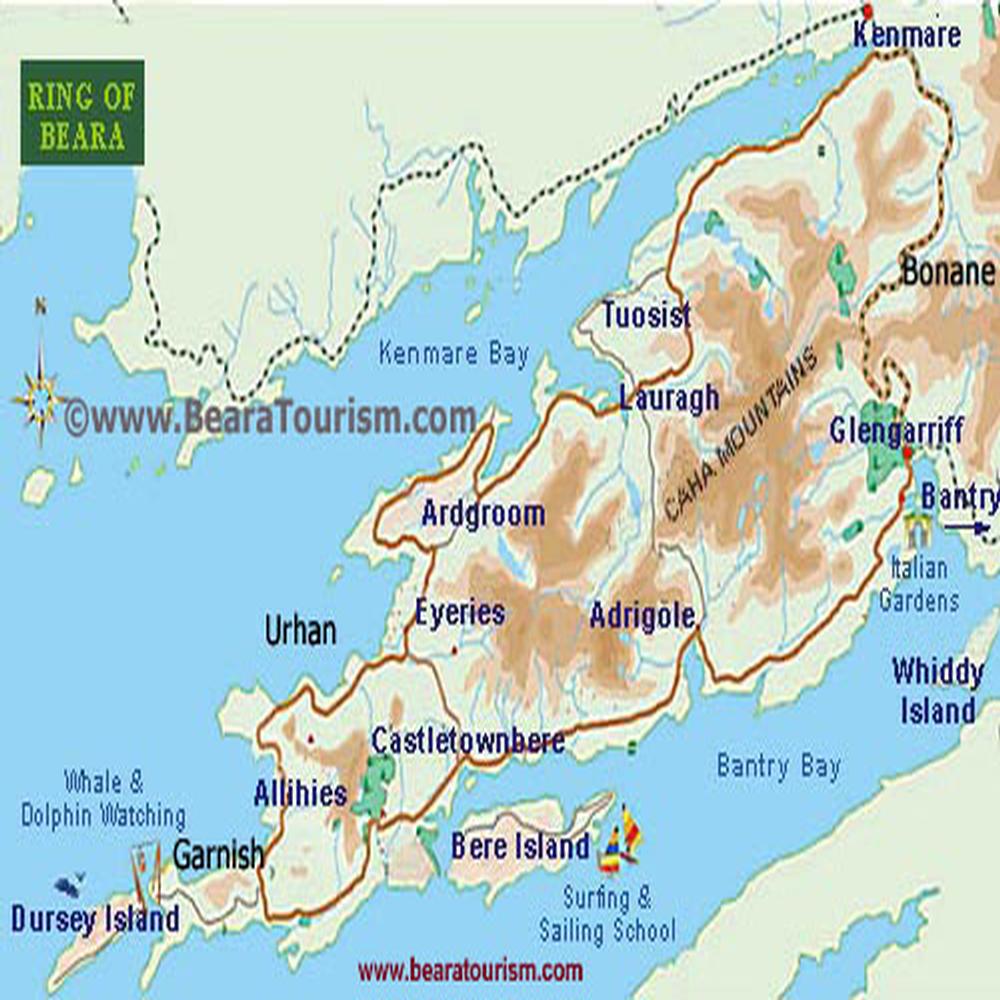